This article needs additional citations for verification. (February 2024) |
| Mow Cop | |
|---|---|
 | |
Location within Staffordshire Location within Cheshire | |
| OS grid reference | SJ855573 |
| Civil parish | |
| District | |
| Unitary authority | |
| Shire county | |
| Ceremonial county | |
| Region | |
| Country | England |
| Sovereign state | United Kingdom |
| Post town | STOKE-ON-TRENT |
| Postcode district | ST7 |
| Dialling code | 01782 |
| Police | Cheshire |
| Fire | Cheshire |
| Ambulance | North West |
| West Midlands | |
| UK Parliament | |
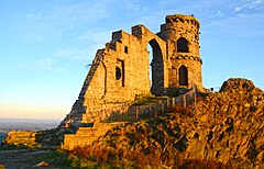
Mow Cop /ˈmaʊˈkɒp/ is a village split between Cheshire and Staffordshire, and therefore divided between the North West and West Midlands regions of England. It is 24 miles (39 km) south of Manchester and 6 miles (9.7 km) north of Stoke-on-Trent, on a steep hill of the same name rising to 335 metres (1,099 ft) above sea level.[1] The village is at the edge of the southern Pennines, with the Cheshire Plain directly to the west. For population details taken at the 2011 census, see Kidsgrove. The Cheshire section is the highest settlement within the county of Cheshire.
- ^ "Mow Cop – Trig Point". Hill Bagging. Retrieved 29 April 2016.


