Back মুবাত্তুপ্পি Bengali/Bangla মুবাত্তুপুয্হ BPY Muvattupuzha CEB Muvattupuzha Spanish مواتوتوپوزا Persian मूवाट्टुपुड़ा Hindi Muvattupuzha Italian Muvattupuzha Malagasy മൂവാറ്റുപുഴ Malayalam Muvattupuzha Malay
Muvattupuzha | |
|---|---|
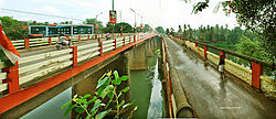
 Muvattupuzha Old and New Bridges | |
Location in Kerala | |
| Coordinates: 9°58′47″N 76°34′49″E / 9.9798°N 76.5803°E | |
| Country | |
| State | Kerala |
| District | Ernakulam |
| Government | |
| • Type | Municipality |
| • Municipal Chairman | P P Eldhose |
| Area | |
| • Total | 13.18 km2 (5.09 sq mi) |
| Elevation | 15 m (49 ft) |
| Population (2011) | |
| • Total | 30,397 |
| • Density | 2,300/km2 (6,000/sq mi) |
| Languages | |
| • Official | Malayalam, English |
| Time zone | UTC+5:30 (IST) |
| PIN | 686661(Kacherithazham), 686673(Velloorkunnam), 686662, 63, 64, 65, 66, 67, 68, 69, 70, 71 (Adivad), , 72, 682316, 682308 |
| Telephone code | 0485 |
| Vehicle registration | KL-17 |
| Nearest city | Kochi |
| Sex ratio | 1023 ♂/♀ |
| Legislative assembly constituency | Muvattupuzha |
| Lok Sabha constituency | Idukki |
| Climate | Tropical monsoon (Köppen) |
| Avg. summer temperature | 32.5 °C (90.5 °F) |
| Avg. winter temperature | 20 °C (68 °F) |


Muvattupuzha ([muʋɐːt̺ːupuɻɐ]) is a municipality[2] in the Ernakulam district of Kerala, India. It is located 26 km (16.2 mi) east of the district headquarters in Thrikkakara and about 170 km (105.6 mi) north of the state capital Thiruvananthapuram. As per the 2011 Indian census, Muvattupuzha has a population of 30,397 people, and a population density of 2,306/km2 (5,970/sq mi).
Muvattupuzha is bordered by the Kottayam district on the southern side and the Idukki district on the eastern side. Muvattupuzha lies on the intersection between MC Road and National Highway 49, about 28 km (17 mi) from the district capital Ernakulam. Muvattupuzha is located 20 km (12 mi) from Thodupuzha, 17 km (11 mi) from Koothattukulam, and 5 km (3.1 mi) away from Arakuzha.

