Back Nagano Afrikaans ناغانو (ناغانو) Arabic ناجانو ARZ Naqano Azerbaijani ناقانو (شهر) AZB Нагано Bashkir Нагана Byelorussian Нагано (град) Bulgarian নাগানো Bengali/Bangla Nagano Breton
Nagano
長野市 | |
|---|---|
![From top of left, Zenkoji, Mount Togakushi, Kinasa village, Nagano Big Hat arena, Aerial in Kawanakajima, Susobana Valley [ja], headquarters of Marukome (famous miso manufacturing company) in Nagano, Oyaki Japanese sweets a.k.a. Imagawayaki, Togakushi ski resort [ja], and Matsushiro Castle](http://upload.wikimedia.org/wikipedia/commons/thumb/7/79/Nagano_montages.JPG/250px-Nagano_montages.JPG) From top of left, Zenkoji, Mount Togakushi, Kinasa village, Nagano Big Hat arena, Aerial in Kawanakajima, Susobana Valley, headquarters of Marukome (famous miso manufacturing company) in Nagano, Oyaki Japanese sweets a.k.a. Imagawayaki, Togakushi ski resort, and Matsushiro Castle | |
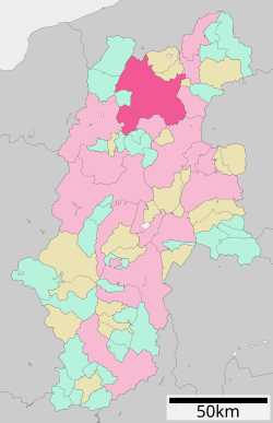
 Location of Nagano in Nagano Prefecture | |
 | |
| Coordinates: 36°38′55″N 138°11′41″E / 36.64861°N 138.19472°E | |
| Country | Japan |
| Region | Chūbu (Kōshin'etsu) |
| Prefecture | Nagano |
| Government | |
| • Mayor | Kenji Ogiwara[1] |
| Area | |
• Total | 834.81 km2 (322.32 sq mi) |
| Population (July 1, 2023) | |
• Total | 365,296 |
| • Density | 440/km2 (1,100/sq mi) |
| Time zone | UTC+9 (Japan Standard Time) |
| Phone number | 026-226-4911 |
| Address | 1613 Midori-chō, Nagano-shi, Nagano-ken 380-8512 |
| Climate | Cfa/Dfa |
| Website | Official website |
| Symbols | |
| Flower | Apple |
| Tree | Japanese Lime (Tilia japonica) |
Nagano (長野市, Nagano-shi, pronounced [naganoꜜ ɕi][2]) is the capital and largest city of Nagano Prefecture, located in the Nagano Basin (Zenkoji Daira) in the central Chūbu region of Japan. Nagano is categorized as a core city of Japan. Nagano City is the highest prefectural capital in Japan, with an altitude of 371.4 meters (1,219 ft).[3] The city is surrounded by mountains, the highest of which is Mount Takatsuma (2,353 m), and it is near the confluence of the Chikuma River—the longest and widest river in Japan—and the Sai River. As of 1 July 2023[update], the city had an estimated population of 365,296 in 160,625 households, and a population density of 438 persons per km².[4] The total area of the city is 834.81 square kilometres (322.32 sq mi).
- ^ "歴代長野市長 (trans. Mayors of Nagano City)". Nagano City. Nagano City Official Website. Retrieved 17 November 2021.
- ^ "ながの". NHK日本語発音アクセント新辞典. NHK.
- ^ 長野県庁(画面左下に標高表示) - 国土地理院地図
- ^ 市政情報 > 市の沿革・概要 > 人口・面積・自然 (in Japanese).


