Back Naissaar Azerbaijani Найссаар Byelorussian Naissaar CEB Naissaar Czech Naissaar Danish Naissaar German Naissaar Spanish Naissaar Estonian Naissaari Finnish Naissaar French


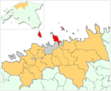
Naissaar (Swedish: Nargö; German: Nargen) is an island in Estonia. It is located in the Gulf of Finland, northwest of the capital city Tallinn, and is administratively part of Viimsi Parish. The island has an area of 18.6 square kilometres (7.2 square miles). It is 8 kilometres (5.0 miles) long and 3.5 kilometres (2.2 miles) wide, and lies about 8.5 kilometres (5.3 miles) from the mainland. The highest point on the island is Kunilamägi, which is 27 metres (89 feet) above sea level. The island consists predominantly of coniferous forest and piles of stones and boulders. In 2020, the island had a population of 17; in 2011 the island had about 35 permanent residents and some summer residents.

Until the Second World War, the island's population numbered about 450 people of Estonian-Swedish origin. However, these people fled during the war. Naissaar under Soviet rule was a military area and off-limits to the public. After the Second World War, the settlement on the entire island were combined into a single village called Naissaare. In 2011, this was re-divided into the three historical villages of Lõunaküla (Storbyn), Tagaküla (Bakbyn), and Väikeheinamaa (Lillängin).[1]
Although the fortifications on the island date back to Peter the Great's scheme to fortify Tallinn, the main fortifications are from the period of Russian rule before World War I. Today, the previous small houses of the Swedish villages are gradually being restored. Also being restored is a narrow gauge railway that runs from the north to the southern tip of the island.
A notable native of the island was Bernhard Schmidt, the German-Estonian optician who invented the Schmidt telescope in 1930.
- ^ "Naissaare". Dictionary of Estonian Place Names. Tallinn: Eesti Keele Instituut. Retrieved 4 April 2024.