Back ناباني Arabic نابانى ARZ ناپانی، ایندیانا AZB Nappanee Catalan Наппани (Индиана) CE Nappanee CEB Nappanee, Indiana Welsh Nappanee DAG Nappanee German Nappanee (Indiana) Spanish
Nappanee, Indiana | |
|---|---|
 Downtown Nappanee | |
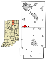
 Location of Nappanee in Elkhart County and Kosciusko County, Indiana. | |
| Coordinates: 41°26′48″N 85°59′58″W / 41.44667°N 85.99944°W | |
| Country | United States |
| State | Indiana |
| Counties | Elkhart, Kosciusko |
| Government | |
| • Mayor | Phil Jenkins (R)[citation needed] |
| Area | |
| • Total | 4.78 sq mi (12.37 km2) |
| • Land | 4.78 sq mi (12.37 km2) |
| • Water | 0.00 sq mi (0.00 km2) 0% |
| Elevation | 863 ft (263 m) |
| Population (2020) | |
| • Total | 6,949 |
| • Density | 1,455.29/sq mi (561.91/km2) |
| Time zone | UTC-5 (Eastern (EST)) |
| • Summer (DST) | UTC-4 (EDT) |
| ZIP code | 46550 |
| Area code | 574 |
| FIPS code | 18-52020[3] |
| GNIS feature ID | 2395150[2] |
| Website | http://www.nappanee.org/ |
Nappanee is a city in Elkhart and Kosciusko counties in the U.S. state of Indiana. The population was 6,648 as of the 2010 U.S. Census and had grown to 6,913 by the 2020 U.S. Census.[4] The name Nappanee is thought to mean "flour" in the Algonquian language.[5]
- ^ "2020 U.S. Gazetteer Files". United States Census Bureau. Retrieved March 16, 2022.
- ^ a b U.S. Geological Survey Geographic Names Information System: Nappanee, Indiana
- ^ "U.S. Census website". United States Census Bureau. Retrieved January 31, 2008.
- ^ "U.S. Census Bureau Quick Facts".
- ^ "Nappanee - Indiana, United States". Britannica.com. Retrieved August 27, 2017.