Back Newry, Mourne and Down German Distrito de Newry, Mourne y Down Spanish نیوری، مورن و داون Persian District de Newry, Mourne and Down French Newry, Mourne and Down FRR Distretto di Newry, Mourne e Down Italian ニューリー・モーン・アンド・ダウン Japanese Newry, Mourne and Down Dutch Newry, Mourne and Down Swedish Newry, Mourne and Down Turkish
Newry, Mourne and Down
| |
|---|---|
District | |
 | |
| Coordinates: 54°06′40″N 6°09′40″W / 54.111°N 6.161°W | |
| Sovereign state | United Kingdom |
| Constituent country | Northern Ireland |
| Status | District |
| Incorporated | 1 April 2015 |
| Government | |
| • Type | District council |
| • Body | Newry, Mourne and Down District Council |
| Area | |
| • Total | 629 sq mi (1,628 km2) |
| Population (2022) | |
| • Total | 182,634 |
| • Density | 290/sq mi (110/km2) |
| Time zone | UTC0 (GMT) |
| • Summer (DST) | UTC+1 (BST) |
| ISO 3166 code | GB-NMD |
| Ethnicity | 98.3% White[1] |
| Website | www |
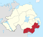
Newry, Mourne and Down is a local government district in Northern Ireland that was created on 1 April 2015 by merging Newry and Mourne District and Down District. It covers most of the southeastern part of Northern Ireland. The local authority is Newry, Mourne and Down District Council. The principal population centres are Newry in the south of the district, and Downpatrick in the north; both these urban areas were seats of previous council areas.
- ^ "Main statistics for Northern Ireland Statistical bulletin—Ethnic group" Office for National Statistics. Retrieved 22 September 2022