Back نيوتونيا (ميزوري) Arabic Newtonia Catalan Newtonia (lungsod sa Tinipong Bansa) CEB Newtonia, Missouri Welsh Newtonia (Misuri) Spanish Newtonia (Missouri) Basque نیوتنیا، میسوری Persian Newtonia (Missouri) French Newtonia, Missouri HT Newtonia (Missouri) Italian
Newtonia, Missouri | |
|---|---|
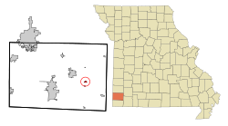
 Location of Newtonia, Missouri | |
| Coordinates: 36°52′46″N 94°11′01″W / 36.87944°N 94.18361°W[1] | |
| Country | United States |
| State | Missouri |
| County | Newton |
| Area | |
| • Total | 0.33 sq mi (0.85 km2) |
| • Land | 0.33 sq mi (0.85 km2) |
| • Water | 0.00 sq mi (0.00 km2) |
| Elevation | 1,191 ft (363 m) |
| Population (2020) | |
| • Total | 204 |
| • Density | 625.77/sq mi (241.24/km2) |
| Time zone | UTC-6 (Central (CST)) |
| • Summer (DST) | UTC-5 (CDT) |
| ZIP code | 64853 |
| Area code | 417 |
| FIPS code | 29-52292[3] |
| GNIS feature ID | 2396814[1] |
Newtonia is a village in Newton County, Missouri, United States. The population was 199 at the 2010 census. It is part of the Joplin, Missouri Metropolitan Statistical Area. Newtonia was the site of the Battles of Newtonia during the American Civil War. The village contains some Antebellum houses, such as the Mathew H. Ritchey House, as well as a cemetery for Civil War dead. It is a farming community and is immediately adjacent to Stark City, Missouri.
- ^ a b c U.S. Geological Survey Geographic Names Information System: Newtonia, Missouri
- ^ "ArcGIS REST Services Directory". United States Census Bureau. Retrieved August 28, 2022.
- ^ "U.S. Census website". United States Census Bureau. Retrieved January 31, 2008.