Back Ngara (distrito) CEB Ngara (Distrikt) German Ngara (Kagera) Spanish Distretto di Ngara Italian Wilaya ya Ngara Swahili Ngara (huyện) Vietnamese Ngara District Zulu
Ngara District
Wilaya ya Ngara | |
|---|---|
 Ngara District of Kagera Region | |
| Coordinates: 2°38′00″S 30°41′00″E / 2.633333°S 30.683333°E | |
| Country | |
| Region | Kagera Region |
| Government | |
| • Type | Council |
| • Body | Ngara District Council |
| • District Commissioner | Mathias Julius Kahabi (TPDF) |
| • District Secretary | Vedastus Tibaijuka |
| • Chairman of Council | Wilbard Bambala |
| Area | |
| • Total | 3,305 km2 (1,276 sq mi) |
| Elevation | 1,800 m (5,900 ft) |
| Population (2022) | |
| • Total | 383,092 |
| • Density | 120/km2 (300/sq mi) |
| Time zone | UTC+3 (EAT) |
| Area code | 028 |
| Website | District Website |
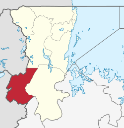
Ngara District is one of the eight districts of the Kagera Region of Tanzania. It is bordered to the north by Karagwe District, to the east by Biharamulo District, to the south by the Kigoma Region, to the northeast by Muleba District and to the west by the countries of Rwanda and Burundi.[1]
According to the 2012 Tanzania National Census, the population of the Ngara District was 320,056, from 334,409 in 2002, and 159,546 in 1988, with an estimated population of 365,661 in 2017. The population density is 110 inhabitants per square kilometre (280/sq mi). There are 22 wards, 75 villages, and 389 suburbs in Ngara.[2][3]
- ^ Cite error: The named reference
Ngara_dcwas invoked but never defined (see the help page). - ^ "2002 Census Analytical Report". Tanzania National Bureau of Statistics (in Swahili). Dodoma, Tanzania: National Bureau of Statistics (Tanzania). p. 17. Retrieved 2 July 2022.
- ^ "Tanzania National Census 2012". National Bureau of Statistics. Dodoma, Tanzania. March 2013. p. 164. Retrieved 1 July 2022.