Back Niagara Ēa ANG نياجارا Arabic نهر نياجارا ARZ Niaqara çayı Azerbaijani Niagara River BAR Ніягара Byelorussian Ниагара (река) Bulgarian নায়াগ্রা নদী Bengali/Bangla Niagara BS Riu Niàgara Catalan
| Niagara River | |
|---|---|
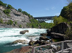
 The Niagara River at Niagara Gorge in May 2008 | |
| Location | |
| Countries | |
| Province / State | |
| Physical characteristics | |
| Source | Lake Erie |
| • elevation | 173.43 m (569 ft)[1] |
| Mouth | Lake Ontario |
• coordinates | 43°04′41″N 79°04′37″W / 43.078°N 79.077°W |
• elevation | 74.1 m (243 ft)[2] |
| Length | 58 km (36 mi)[3] |
| Basin size | 684,000 km2 (264,000 sq mi)[3] |
| Discharge | |
| • average | 5,796 m3/s (204,700 cu ft/s)[4] |
| Basin features | |
| Progression | Lake Ontario→ Saint Lawrence River→ Gulf of Saint Lawrence |
| Tributaries | |
| • left | Welland River |
| • right | Tonawanda Creek |
| Official name | Niagara River Corridor |
| Designated | 3 October 2019 |
| Reference no. | 2402[5] |


The Niagara River (/naɪˈæɡərə, -ɡrə/ ny-AGG-ər-ə, -grə) flows north from Lake Erie to Lake Ontario, forming part of the border between Ontario, Canada, to the west, and New York, United States, to the east. The origin of the river's name is debated. Iroquoian scholar Bruce Trigger suggests it is derived from a branch of the local Neutral Confederacy, referred to as the Niagagarega people on several late-17th-century French maps.[6] George R. Stewart posits that it comes from an Iroquois town named Ongniaahra, meaning "point of land cut in two."[7]
The river, occasionally described as a strait,[8] is approximately 58 kilometres (36 mi) long and includes Niagara Falls. Over the past 12,000 years, the falls have moved roughly 11 kilometres (6.8 mi) upstream from the Niagara Escarpment, creating a gorge below the falls. Today, the diversion of the river for electricity generation has significantly slowed the rate of erosion. The total elevation drop along the river is 99 metres (325 ft). The Niagara Gorge, downstream from the falls, includes the Niagara Whirlpool and additional rapids.
Power plants on the river include the Sir Adam Beck Hydroelectric Generating Stations (built in 1922 and 1954) on the Canadian side, and the Robert Moses Niagara Power Plant (built in 1961) on the American side, collectively generating 4.4 gigawatts of electricity. The International Control Dam, constructed in 1954, regulates river flow. Ships on the Great Lakes use the Welland Canal, part of the St. Lawrence Seaway, on the Canadian side of the river, to bypass Niagara Falls.
The Niagara River features two large islands and several smaller ones. Grand Island and Navy Island, the two largest, are on the American and Canadian sides, respectively. Goat Island and the small Luna Island divide Niagara Falls into three sections: Horseshoe Falls, Bridal Veil Falls, and American Falls. Unity Island lies further upstream, adjacent to the city of Buffalo.
The Niagara River and its tributaries, Tonawanda Creek and the Welland River, formed part of the final section of the Erie Canal and Welland Canal. After leaving Lockport, the Erie Canal heads southwest into Tonawanda Creek. Upon entering the Niagara River, watercraft proceed south to the final lock, where a short canal section allows boats to bypass turbulent shoal water and enter Lake Erie. The Welland Canals used the Welland River to connect to the Niagara River south of the falls, enabling water traffic to safely re-enter the river and continue to Lake Erie.
- ^ Inferred from Lake Erie. Retrieved 2021-01-30.
- ^ Inferred from Lake Ontario. Retrieved 2021-01-30.
- ^ a b "Facts & Figures - Niagara Parks, Niagara Falls, Ontario, Canada". Archived from the original (online) on December 9, 2003. Retrieved May 30, 2007.
- ^ Water Resources Data New York Water Year 2003, Volume 3: Western New York, USGS
- ^ "Niagara River Corridor". Ramsar Sites Information Service. Archived from the original on 14 January 2020. Retrieved 9 January 2020.
- ^ Bruce Trigger, The Children of Aataentsic (McGill-Queen's University Press, Kingston and Montreal,1987, ISBN 0-7735-0626-8), p. 95.
- ^ Stewart, George R. (1967) Names on the Land. Boston: Houghton Mifflin Company; p. 83.
- ^ Mobot.org


