Back Nightcap National Park CEB Nightcap-Nationalpark German Parque nacional Nightcap Spanish നൈറ്റ്ക്യാപ്പ് ദേശീയോദ്യാനം Malayalam Nationaal park Nightcap Dutch Park Narodowy Nightcap Polish Nightcap National Park Swedish
| Nightcap National Park New South Wales | |
|---|---|
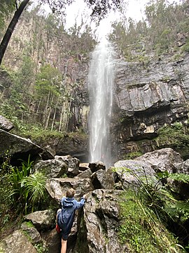
 Protesters Falls in the ancient rainforest of Nightcap National Park | |
| Nearest town or city | Lismore |
| Coordinates | 28°32′38″S 153°17′35″E / 28.54389°S 153.29306°E |
| Established | 22 April 1983 |
| Area | 81 km2 (31.3 sq mi)[1] |
| Managing authorities | NSW National Parks & Wildlife Service |
| Website | Nightcap National Park |
| See also | Protected areas of New South Wales |

The Nightcap National Park is a national park situated within the Nightcap Range in the Northern Rivers region of New South Wales, Australia.[2] The 8,080-hectare (20,000-acre) park was created in April 1983[1] and is situated 35 kilometres (22 mi) north of Lismore. The park was established following campaigns and blockades against logging at Terania Creek, Grier's Scrub and Mount Nardi between 1979 and 1982. Sections of the Whian Whian state forest were added to it following blockading and campaigning in 1998.[3] The national park is classed by the IUCN World Commission on Protected Areas as Category II and is part of the Shield Volcano Group of the World Heritage Site Gondwana Rainforests of Australia inscribed in 1986 and added to the Australian National Heritage List in 2007.
- ^ a b "Nightcap National Park". Office of the Environment & Heritage. Government of New South Wales. Retrieved 10 May 2015.
- ^ "Nightcap National Park". Google Maps. Retrieved 4 August 2019.
- ^ McIntyre, Iain (4 November 2020). "Environmental Blockading in Australia and Around the World - Timeline 1974-1997". The Commons Social Change Library. Retrieved 7 July 2023.
