Back شط تسعين ميل ARZ নব্বই মাইল সমুদ্র সৈকত (অস্ট্রেলিয়া) Bengali/Bangla Ninety Mile Beach (lapyahan sa Ostralya, State of Victoria, Wellington) CEB Ninety Mile Beach (Victoria) German Ninety Mile Beach (strand i Australien, Victoria, Wellington) Swedish
Ninety Mile | |
|---|---|
Beach | |
 | |
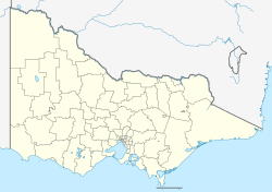
Location of the Ninety Mile Beach in Victoria | |
| Coordinates: 38°18′8″S 147°17′15″E / 38.30222°S 147.28750°E | |
| Location | East Gippsland, Australia |
This article needs additional citations for verification. (August 2007) |
The Ninety Mile Beach is a sandy stretch of beach on the south-eastern coastline of the East Gippsland region of Victoria in Australia. The beach faces Bass Strait and backs the Gippsland Lakes. The beach is just over 151 kilometres (94 mi) in length, running north-eastward from a spit near Port Albert to the man-made channel at Lakes Entrance.
Behind the beach are long sandy dunes that separate the Gippsland Lakes from Bass Strait.[1] The beach is an uninterrupted stretch of untamed coastline; it does not have any rocky headlands or platforms, and offshore there are only a few ribbons of reef which are periodically covered by sand.[2]
In the northern section, the beach runs along a sandbar on what amounts to a series of tidal islands. Behind this are several large lakes and numerous shallow littoral lagoons. The three main lakes are Lake King, Lake Victoria and Lake Wellington, partially contained within The Lakes National Park.
- ^ "Ninety Mile Beach, Gippsland, Victoria, Australia". Tourism Victoria home. Retrieved 21 June 2015.
- ^ "Parks Victoria - Ninety Mile Beach Marine National Park". parkweb.vic.gov.au. Retrieved 21 June 2015.
