Back قناة بحر الشمال Arabic قناة بحر الشمال ARZ Canal de la mar del Nord Catalan Noordzeekanaal CEB Nordseekanal German Nordmara kanalo Esperanto Canal del mar del Norte Spanish Canal de la Mer du Nord French Noardseekanaal Frisian Északi-tengeri-csatorna Hungarian
| North Sea Canal | |
|---|---|
 | |
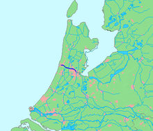
 Location of canal in dark blue. | |
| Native name | Noordzeekanaal (Dutch) |
| Location | |
| Country | Netherlands |
| Province | North Holland |
| Physical characteristics | |
| Source | IJ |
| • location | Amsterdam |
| • coordinates | 52°23′45″N 4°53′30″E / 52.39583°N 4.89167°E |
| Mouth | North Sea |
• location | IJmuiden |
• coordinates | 52°27′50″N 4°33′30″E / 52.46389°N 4.55833°E |
• elevation | 0 m (0 ft) |
| Length | 25 km (16 mi) |
The North Sea Canal (Dutch: Noordzeekanaal) is a Dutch ship canal from Amsterdam to the North Sea at IJmuiden, constructed between 1865 and 1876 to enable seafaring vessels to reach the port of Amsterdam.[1] This man-made channel terminates at Amsterdam in the closed-off IJ Bay, which in turn connects to the Amsterdam-Rhine Canal.
The drainage of the canal to the North Sea is done through the IJmuiden sea lock, augmented by the largest pumping station in Europe. This system is vital to the groundwater management of the Western Netherlands.
- ^ A bird's-eye view of the Canal[permanent dead link] at the Amsterdam City Archives