Back نهر نوكوبى ARZ Noxubee River (suba sa Tinipong Bansa, Mississippi) CEB Noxubee River German Noxubee (rivière) French
| Noxubee River | |
|---|---|
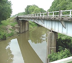
 A bridge crossing of the Noxubee River at Macon, Mississippi | |
| Location | |
| Country | United States |
| State | Alabama and Mississippi |
| Physical characteristics | |
| Source | |
| • coordinates | 33°18′12″N 89°08′51″W / 33.3033333°N 89.1475°W |
| • elevation | 619 ft (189 m) |
| Mouth | |
• coordinates | 32°49′42″N 88°10′45″W / 32.8283333°N 88.1791667°W |
• elevation | 75 ft (23 m) |
| Length | 91 mi (146 km) |
| Basin features | |
| Progression | Noxubee River → Tombigbee River → Mobile River → Gulf of Mexico |
| GNIS ID | 158173 |

The Noxubee River (NAHKS-uh-bee) is a tributary of the Tombigbee River, about 90.6 miles (145.8 km) long, in east-central Mississippi and west-central Alabama in the United States.[1][2][3] Via the Tombigbee, it is part of the watershed of the Mobile River, which flows to the Gulf of Mexico.
- ^ "Noxubee River". Geographic Names Information System. United States Geological Survey. Retrieved 2015-09-13.
- ^ "Noxubee River". Geographic Names Information System. United States Geological Survey. Retrieved 2015-09-13.
- ^ "Station 02448000 NOXUBEE RIVER AT MACON, MS". USGS Hydro-Climatic Data Network (HCDN). United States Geological Survey (USGS). Retrieved 2015-09-13.