Back Nyngan CEB Nyngan German نینگان Persian Nyngan French Nyngan Malagasy Nyngan Polish Nyngan, New South Wales SIMPLE Nyngan Swedish
| Nyngan New South Wales | |||||||||
|---|---|---|---|---|---|---|---|---|---|
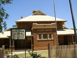
 Court house, Nyngan | |||||||||
| Coordinates | 31°34′0″S 147°12′0″E / 31.56667°S 147.20000°E | ||||||||
| Population | 1,953 (2021 census)[1] | ||||||||
| Postcode(s) | 2825 | ||||||||
| Elevation | 173 m (568 ft) | ||||||||
| Location |
| ||||||||
| LGA(s) | Bogan Shire | ||||||||
| County | Oxley | ||||||||
| State electorate(s) | Barwon | ||||||||
| Federal division(s) | Parkes | ||||||||
| |||||||||
Nyngan (/ˈnɪŋɡən/) is a town in the centre of New South Wales, Australia, in the Bogan Shire local government area within the Orana Region of central New South Wales. At the 2016 census, Nyngan had a population of 1,988 people.[1] Nyngan is situated on the Bogan River between Narromine and Bourke, on the junction of the Mitchell Highway and Barrier Highway, 656 km (408 mi) south of Charleville and 576 km (358 mi) north-west of Sydney by road. The Barrier Highway starts at Nyngan, and runs west to Cobar and on through Wilcannia and Broken Hill into South Australia.
Nyngan Airport is a small airport just north of the town centre. Nyngan also lies on the Main Western railway line of New South Wales but is no longer served by passenger trains. The line remains open to freight traffic.
About 70 km (43 mi) south of the town, a cairn was erected in 1988 marking the centre of NSW.[2]
- ^ a b Australian Bureau of Statistics (27 June 2017). "Nyngan (Urban Centre/Locality)". 2016 Census QuickStats. Retrieved 1 January 2020.
- ^ Centre of New South Wales Cairn, Monument Australia. Retrieved 11 June 2012
