Back اواتلاندس ARZ Oatlands CEB Oatlands (Tasmanien) German Oatlands (Tasmania) Italian Oatlands Dutch Oatlands (Tasmania) Polish Oatlands, Tasmanien Swedish
| Oatlands Tasmania | |||||||||
|---|---|---|---|---|---|---|---|---|---|
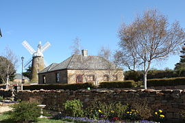
 View of Callington mill. | |||||||||
 Oatlands Coach House, typical sandstone building | |||||||||
| Coordinates | 42°18′00″S 147°22′14″E / 42.30000°S 147.37056°E | ||||||||
| Population | 728 (2021 census)[1] | ||||||||
| Postcode(s) | 7120 | ||||||||
| Elevation | 406 m (1,332 ft)[2] | ||||||||
| Location |
| ||||||||
| LGA(s) | Southern Midlands Council | ||||||||
| State electorate(s) | Lyons | ||||||||
| Federal division(s) | Lyons | ||||||||
| |||||||||
Oatlands is an important historical village on the shores of Lake Dulverton in the centre of Tasmania, Australia. Oatlands is located 84 km north of Hobart and 115 km south of Launceston on the Midland Highway. At the 2021 census, Oatlands had a population of 728.[3]
Oatlands is considered to have the largest number of colonial sandstone buildings in any town in Australia, and many of them were built by convict labour. It is the largest town in the Southern Midlands Council area and is surrounded by rich agricultural land.
- ^ [1]. - Retrieved on 2023-04-06.
- ^ Bureau of Meteorology. - Retrieved on 2007-11-11.
- ^ Australian Bureau of Statistics (28 June 2022). "Oatlands (Tas) (State Suburb)". 2021 Census QuickStats. Retrieved 5 April 2023.
