Back أولد شانيتاون (إلينوي) Arabic Old Shawneetown Catalan Old Shawneetown CEB Old Shawneetown, Illinois Welsh Old Shawneetown (Illinois) Spanish Old Shawneetown (Illinois) Basque Old Shawneetown French Old Shawneetown, Ilinwa HT Old Shawneetown Italian Old Shawneetown (Illinois) LLD
Old Shawneetown, Illinois | |
|---|---|
 Old Shawneetown Court House in 1937 | |
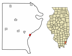
 Location of Old Shawneetown in Gallatin County, Illinois. | |
 Location of Illinois in the United States | |
| Coordinates: 37°41′54″N 88°8′13″W / 37.69833°N 88.13694°W | |
| Country | United States |
| State | Illinois |
| County | Gallatin |
| Area | |
| • Total | 0.51 sq mi (1.32 km2) |
| • Land | 0.51 sq mi (1.32 km2) |
| • Water | 0.00 sq mi (0.00 km2) |
| Elevation | 348 ft (106 m) |
| Population (2020) | |
| • Total | 113 |
| • Density | 221.57/sq mi (85.51/km2) |
| Time zone | UTC-6 (CST) |
| • Summer (DST) | UTC-5 (CDT) |
| ZIP Code(s) | 62984 |
| Area code | 618 |
| FIPS code | 17-55756 |
| GNIS ID | 2399569[2] |
| Wikimedia Commons | Old Shawneetown, Illinois |
Old Shawneetown is a village in Gallatin County, Illinois, United States. As of the 2020 census, the village had a population of 113,[3] down from 193 at the 2010 census.[4] Located along the Ohio River, Shawneetown served as an important United States government administrative center for the Northwest Territory. The village was devastated by the Ohio River flood of 1937. The village's population was moved several miles inland to New Shawneetown.

- ^ "2020 U.S. Gazetteer Files". United States Census Bureau. Retrieved March 15, 2022.
- ^ a b U.S. Geological Survey Geographic Names Information System: Old Shawneetown, Illinois
- ^ "Explore Census Data". data.census.gov. Retrieved June 28, 2022.
- ^ "G001 - Geographic Identifiers - 2010 Census Summary File 1". United States Census Bureau. Archived from the original on February 13, 2020. Retrieved December 25, 2015.