Back Olifantsrivier, Namakwaland Afrikaans نهر اوليفانتس (نهر) ARZ Olifants (Namakwaland) CEB Olifants River (Westkap) German Río Olifants (Provincia Cabo Occidental) Spanish Olifantsas (Vakarų Kapas) Lithuanian Olifantsrivier (Weskus) Dutch Rio Olifants (Cabo Ocidental) Portuguese Улифантс (река, впадает в Атлантический океан) Russian Olifants river, Västra Kapprovinsen Swedish
| Olifants River | |
|---|---|
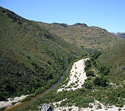
 A view of the Olifants River as it runs through the Winterhoek Mountain range a few kilometres upstream from Citrusdal | |
 Olifants River watershed (Interactive map) | |
| Location | |
| Country | South Africa |
| State | Western Cape Province |
| Physical characteristics | |
| Source | Winterhoek Mountains |
| Mouth | Atlantic Ocean |
• location | near Papendorp |
• coordinates | 31°42′S 18°13′E / 31.700°S 18.217°E |
| Length | 265 km (165 mi) |
| Basin size | 46,220 km2 (17,850 sq mi) |
The Olifants River (Afrikaans: Olifantsrivier) is a river in the northwestern area of the Western Cape Province of South Africa. The upper and main catchment area of the Olifants river is around Ceres and the Cederberg mountains. The Clanwilliam and Bulshoek dams are located on the river and provide water for the towns and farms along the watercourse. The river is approximately 285 km long with a catchment area of 46,220 km2. It flows into the Atlantic Ocean at Papendorp, 250 km north of Cape Town.