Back Olpe AN أولبه Arabic الپه، آلمان AZB Олпе Bulgarian Ольпе CE Olpe (munisipyo) CEB Olpe Czech Olpe German Olpe Esperanto Olpe (Alemania) Spanish
Olpe | |
|---|---|
 Olpe Town Hall, one of the tallest buildings in the town | |
 Coat of arms | |
Location of Olpe within Olpe district 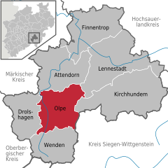 | |
 Olpe  Olpe | |
| Coordinates: 51°01′N 07°50′E / 51.017°N 7.833°E | |
| Country | Germany |
| State | North Rhine-Westphalia |
| Admin. region | Arnsberg |
| District | Olpe |
| Subdivisions | 22 |
| Government | |
| • Mayor (2020–25) | Peter Weber[1] (CDU) |
| Area | |
| • Total | 85.6 km2 (33.1 sq mi) |
| Elevation | 307 m (1,007 ft) |
| Population (2022-12-31)[2] | |
| • Total | 25,015 |
| • Density | 290/km2 (760/sq mi) |
| Time zone | UTC+01:00 (CET) |
| • Summer (DST) | UTC+02:00 (CEST) |
| Postal codes | 57462 |
| Dialling codes | 02761, 02722, 02764 |
| Vehicle registration | OE |
| Website | www.olpe.de |

Olpe is a town situated in the foothills of the Ebbegebirge in North Rhine-Westphalia, roughly 60 km east of Cologne and 20 km northwest of Siegen. It is part of the Regierungsbezirk of Arnsberg and is the seat of the district of Olpe.
- ^ Wahlergebnisse in NRW Kommunalwahlen 2020, Land Nordrhein-Westfalen, accessed 29 June 2021.
- ^ "Bevölkerung der Gemeinden Nordrhein-Westfalens am 31. Dezember 2022 – Fortschreibung des Bevölkerungsstandes auf Basis des Zensus vom 9. Mai 2011" (in German). Landesbetrieb Information und Technik NRW. Retrieved 20 June 2023.