Back أوتارو (هوكايدو) Arabic اوتارو، هوکایدو AZB Отару Bashkir Атару Byelorussian Отару Bulgarian Otaru Catalan Отару CE Otaru-shi CEB Otaru (Hokkaidó) Czech Otaru German
Otaru
小樽市 | |
|---|---|
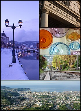
 Top left: Otaru Canal Top right: The Bank of Japan Otaru Museum Middle right 1: - Glass Works in Otaru Middle right 2: - Temiya old railway line Bottom: - Vista from Mount Tengu | |
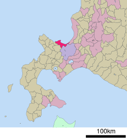
 Location of Otaru in Hokkaido | |
| Coordinates: 43°11′N 141°0′E / 43.183°N 141.000°E | |
| Country | Japan |
| Region | Hokkaido |
| Prefecture | Hokkaido (Shiribeshi Subprefecture) |
| Government | |
| • Mayor | Toshiya Hazama (from August 2018) |
| Area | |
| • Total | 243.83 km2 (94.14 sq mi) |
| Population (July 31, 2023) | |
| • Total | 107,432 |
| • Density | 440/km2 (1,100/sq mi) |
| Time zone | UTC+9 (Japan Standard Time) |
| Phone number | 0134-32-4111 |
| Address | 2-12-1 Hanazono, Otaru-shi, Hokkaido 047-8660 |
| Climate | Dfb |
| Website | www.city.otaru.lg.jp |
| Symbols | |
| Bird | Aobato (Japanese Green Pigeon) |
| Flower | Azalea |
| Tree | Shirakaba (Siberian Silver Birch) |
Otaru (小樽市, Otaru-shi) is a city and port in Shiribeshi Subprefecture, Hokkaido, Japan, northwest of Sapporo. The city faces Ishikari Bay and the Sea of Japan, and has long served as the main port of the bay. With its many historical buildings, Otaru is a popular tourist destination. Because it is a 25-minute drive from Sapporo, it has grown as a commuter town. As of July 31, 2023, the city had an estimated population of 107,432 and a population density of 441 persons per km² (1,100 persons per mi²). The total area is 243.83 km2 (94.14 sq mi). Although it is the largest city in Shiribeshi Subprefecture, the subprefecture's capital is the more centrally located Kutchan.


