Back Otford (bahin nga lungsod) CEB اتفورد، نیو ساوت ولز Persian Otford (Australia) Polish Otford, New South Wales Swedish
| Otford Wollongong, New South Wales | |||||||||||||||
|---|---|---|---|---|---|---|---|---|---|---|---|---|---|---|---|
 | |||||||||||||||
| Coordinates | 34°13′S 151°00′E / 34.217°S 151.000°E | ||||||||||||||
| Population | 369 (2016 census)[1] | ||||||||||||||
| Postcode(s) | 2508 | ||||||||||||||
| Elevation | 172 m (564 ft) | ||||||||||||||
| Location |
| ||||||||||||||
| LGA(s) | City of Wollongong | ||||||||||||||
| State electorate(s) | Heathcote | ||||||||||||||
| Federal division(s) | Cunningham | ||||||||||||||
| |||||||||||||||
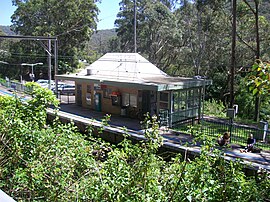
Otford is a village in the Otford Valley located 55 km south of the Sydney and 30 km north of the Wollongong CBD in New South Wales, Australia. Otford is within the local government area of the City of Wollongong.
- ^ Australian Bureau of Statistics (27 June 2017). "Otford (State Suburb)". 2016 Census QuickStats. Retrieved 16 July 2017.
 Material was copied from this source, which is available under a Creative Commons Attribution 4.0 International License.
