Back غابة اوتاوا الوطنيه ARZ Ottawa National Forest (lasang sa Tinipong Bansa, Ontonagon County) CEB 渥太华国家森林 Chinese
| Ottawa National Forest | |
|---|---|
IUCN category VI (protected area with sustainable use of natural resources) | |
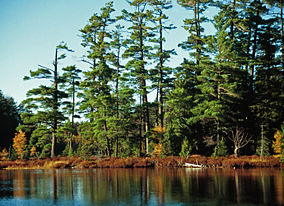
 Pinus strobus, Katherine Lake. Ottawa National Forest, Sylvania Wilderness, Michigan | |
 Map showing National Forests in Michigan. | |
| Location | Upper Peninsula, Michigan, United States |
| Nearest city | Ironwood, Michigan |
| Coordinates | 46°14′N 88°57′W / 46.23°N 88.95°W |
| Area | 993,010 acres (4,020 km2)[1] |
| Established | January 27, 1931[2] |
| Governing body | U.S. Forest Service |
| Website | www |
The Ottawa National Forest is a national forest that covers 993,010 acres (401,860 ha) in the Upper Peninsula of the U.S. state of Michigan. It includes much of Gogebic and Ontonagon counties, as well as slices of Iron, Houghton, Baraga, and Marquette counties. The forest is under the jurisdiction of the U.S. Forest Service.
The headquarters are in Ironwood, Michigan, on the Wisconsin border, and the principal visitor center is located in Watersmeet, Michigan, in the southern section of the Forest. These and other towns within and adjacent to the Forest are served by U.S. Highway 2, one of the principal highways of the Western Upper Peninsula. There are local ranger district offices in Bessemer, Iron River, Kenton, Ontonagon, and Watersmeet.[3]
- ^ "Land Areas of the National Forest System" (PDF). U.S. Forest Service. January 2012. Retrieved 20 June 2012.
- ^ "The National Forests of the United States" (PDF). ForestHistory.org. Retrieved 20 June 2012.
- ^ USFS Ranger Districts by State