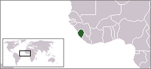

The following outline is provided as an overview of and topical guide to Sierra Leone:
Sierra Leone – sovereign country located in West Africa.[1] Sierra Leone is bordered by Guinea in the northeast, Liberia in the southeast, and the Atlantic Ocean in the southwest. Sierra Leone covers a total area of 71,740 km2 (27,699 sq mi)[2] and has a population of 5,900,000. The country has a tropical climate, with a diverse environment ranging from savannah to rainforests.[3] Freetown is the capital, seat of government, and largest city.[2] Other major cities in the country with a population over 100,000 are Bo, Kenema, Koidu Town and Makeni. Although English is the official language spoken at schools and government administration, Krio (language derived from English and several West African languages and is native to the Sierra Leone Krio people) is the lingua franca spoken throughout the country. The Krio language unites all the different ethnic groups, especially in their trade and interaction with each other.
- ^ "Sierra Leone". The World Factbook. United States Central Intelligence Agency. July 3, 2009. Retrieved July 23, 2009.
- ^ a b Encarta Encyclopedia. "Sierra Leone". Archived from the original on 2008-02-28. Retrieved 2008-02-19.
- ^ The World Guide. "Sierra Leone Geography". Archived from the original on 2009-01-12. Retrieved 2008-02-19.


