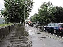
 View northwest along Oxpens Road | |
| Length | 0.3 mi (0.48 km) |
|---|---|
| Postal code | OX1 1 |
| Coordinates | 51°44′59″N 1°15′58″W / 51.74972°N 1.26611°W |
| northwest end | Hollybush Row |
| southeast end | Thames Street |
Oxpens Road is a road in central Oxford, England, linking west and south Oxford.[1] It is named after the marshy area of Oxpens,[2] next to one of the branches of the River Thames in Oxford. It forms part of the A420 road.
- ^ Sherwood, Jennifer; Pevsner, Nikolaus (1974). The Buildings of England: Oxfordshire. Penguin Books. pp. 303, 328. ISBN 0-14-071045-0.
- ^ Tyack, Geoffrey (1998). Oxford: An architectural guide. Oxford University Press. pp. 334–335. ISBN 0-14-071045-0.
