Back Paipa AVK Paipa (munisipyo) CEB Paipa German Paipa Spanish پایپا Persian Paipa French Paipa Galician Paipa Italian პაიპა Georgian Paipa, Boyacá Malay
Paipa | |
|---|---|
Municipality and town | |
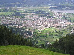
 View of Paipa | |
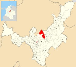
 Location of the municipality and town of Paipa in the Boyacá department of Colombia | |
| Coordinates: 05°50′N 73°09′W / 5.833°N 73.150°W | |
| Country | |
| Department | Boyacá Department |
| Province | Tundama Province |
| Founded | 19 February 1602 |
| Founded by | Luís Enríquez |
| Government | |
| • Mayor | Fabio Alberto Medrano Reyes (2020–2023) |
| Area | |
| • Municipality and town | 305.1 km2 (117.8 sq mi) |
| • Urban | 4.63 km2 (1.79 sq mi) |
| Elevation | 2,525 m (8,284 ft) |
| Population (2018 census)[1] | |
| • Municipality and town | 33,535 |
| • Density | 110/km2 (280/sq mi) |
| • Urban | 20,021 |
| • Urban density | 4,300/km2 (11,000/sq mi) |
| Time zone | UTC-5 (Colombia Standard Time) |
| Website | Official website |
Preview warning: Page using Template:Infobox settlement with unknown parameter "temperature"
Paipa is a town and municipality in the Tundama Province, a part of the Colombian department of Boyacá. Paipa borders Duitama, Firavitoba, Tibasosa, Sotaquirá and Tuta.[2]
- ^ Citypopulation.de Population of Paipa municipality with localities
- ^ (in Spanish) Official website Paipa Archived 2014-03-10 at archive.today

