Back Palm Springs Internasionale Lughawe Afrikaans مطار بالم سبرينجز الدولى ARZ Palm Springs International Airport CEB Palm Springs International Airport German Aeropuerto Internacional de Palm Springs Spanish فرودگاه بینالمللی پام اسپرینگز Persian Aéroport international de Palm Springs French Bandar Udara Internasional Palm Springs ID Aeroporto Internazionale di Palm Springs Italian パームスプリングス国際空港 Japanese
This article needs additional citations for verification. (June 2018) |
Palm Springs International Airport Palm Springs Army Airfield | |||||||||||||||
|---|---|---|---|---|---|---|---|---|---|---|---|---|---|---|---|
 | |||||||||||||||
 | |||||||||||||||
| Summary | |||||||||||||||
| Airport type | Public | ||||||||||||||
| Owner | City of Palm Springs | ||||||||||||||
| Operator | City of Palm Springs Aviation Department | ||||||||||||||
| Serves | Palm Springs Area, Inland Empire | ||||||||||||||
| Location | Palm Springs, California | ||||||||||||||
| Elevation AMSL | 476 ft / 145 m | ||||||||||||||
| Coordinates | 33°49′47″N 116°30′24″W / 33.82972°N 116.50667°W | ||||||||||||||
| Website | flypsp | ||||||||||||||
| Maps | |||||||||||||||
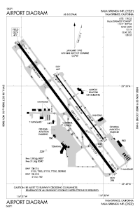
 FAA airport diagram | |||||||||||||||
 | |||||||||||||||
| Runways | |||||||||||||||
| |||||||||||||||
| Statistics (2023) | |||||||||||||||
| |||||||||||||||
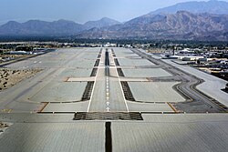
Palm Springs International Airport (IATA: PSP, ICAO: KPSP, FAA LID: PSP), formerly Palm Springs Municipal Airport, is an airport two miles east of downtown Palm Springs, California, United States. The airport covers 940 acres and has two runways.[3][4] The facility operates year-round, with most flights occurring in the fall, winter, and spring.
The airport was named as number 3 in a 2011 list of "America's Most Stress-Free Airports" by Smarter Travel.[5]
- ^ "PSP Statistical Data". City of Palm Springs. January 2019. Archived from the original on July 8, 2019. Retrieved April 25, 2019.
- ^ "PSP airport Passenger Statistics for 2023" (PDF). flypsp.com.com. Retrieved February 1, 2024.
- ^ a b FAA Airport Form 5010 for PSP PDF, effective January 25, 2024.
- ^ "PSP airport data at skyvector.com". skyvector.com. Retrieved September 7, 2022.
- ^ "America's Most Stress-Free Airports". SmarterTravel.com. April 5, 2011.