Back نهر بالمر Arabic نهر بالمر ARZ Palmer River (Mitchell River) German پالمر ریور Persian പാമെർ നദി Malayalam Полмр ревир Tajik
| Palmer | |
|---|---|
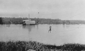
 A gold mining dredge on the Palmer River | |
Location of Palmer River mouth in Queensland | |
| Etymology | In honour of Sir Arthur Hunter Palmer[1] |
| Location | |
| Country | Australia |
| State | Queensland |
| Region | Far North Queensland |
| Physical characteristics | |
| Source | Sussex Range, Great Dividing Range |
| Source confluence | Prospect Creek and Campbell Creek |
| • location | near Palmer River Roadhouse |
| • coordinates | 16°06′18″S 144°46′52″E / 16.10500°S 144.78111°E |
| • elevation | 429 m (1,407 ft) |
| Mouth | confluence with the Mitchell River |
• location | northeast of Staaten River National Park |
• coordinates | 16°04′52″S 142°42′49″E / 16.08111°S 142.71361°E |
• elevation | 64 m (210 ft) |
| Length | 327 km (203 mi) |
| Basin size | 8,335 km2 (3,218 sq mi) |
| Basin features | |
| River system | Mitchell River catchment |
| Tributaries | |
| • left | South Palmer River |
| • right | Little Palmer River, North Palmer River |
| [2] | |
The Palmer River is a river in Far North Queensland, Australia. The area surrounding the river was the site of a gold rush in the late 19th century which started in 1873.
- ^ Cite error: The named reference
qpwas invoked but never defined (see the help page). - ^ "Map of Palmer River, QLD". Bonzle Digital Atlas of Australia. Retrieved 2 December 2015.
