Back بارادايس Arabic بارادايس (منطقه فى امريكا) ARZ پارادیس، نوادا AZB Парадайз (Невада) Byelorussian Парадайс (Невада) Bulgarian Paradise (Nevada) Catalan Paradise (lungsod sa Tinipong Bansa, Nevada) CEB Paradise (Nevada) Czech Paradise (Nevada) Danish Paradise (Nevada) German
Paradise | |
|---|---|
 The Las Vegas Strip, largely located within Paradise | |
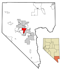
 Location of Paradise in Clark County, Nevada | |
 | |
| Coordinates: 36°4′55″N 115°7′29″W / 36.08194°N 115.12472°W | |
| Country | United States |
| State | Nevada |
| County | Clark |
| Founded | December 8, 1950 |
| Founded by | Clark County Commission |
| Named for | Paradise Valley |
| Area | |
• Total | 42.40 sq mi (109.83 km2) |
| • Land | 42.40 sq mi (109.83 km2) |
| • Water | 0.00 sq mi (0.00 km2) |
| Elevation | 2,057 ft (627 m) |
| Population (2020) | |
• Total | 191,238 |
| • Density | 4,509.90/sq mi (1,741.28/km2) |
| Time zone | UTC−08:00 (PST) |
| • Summer (DST) | UTC−07:00 (PDT) |
| Area codes | 702 and 725 |
| FIPS code | 32-54600 |
| GNIS feature ID | 0845094 |
| Website | clarkcountynv.gov/paradise |
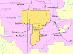
Paradise is an unincorporated town[2] and census-designated place (CDP) in Clark County, Nevada, United States, adjacent to the city of Las Vegas. It was formed on December 8, 1950. Its population was 191,238 at the 2020 census, making it the fifth-most-populous CDP in the United States; if it were an incorporated city, it would be the fifth-largest in Nevada.[3] As an unincorporated town, it is governed by the Clark County Commission with input from the Paradise Town Advisory Board.
Paradise contains Harry Reid International Airport, the University of Nevada, Las Vegas (UNLV), most of the Las Vegas Strip, and most of the tourist attractions in the Las Vegas area (excluding downtown). However, all Paradise addresses, as well as other unincorporated areas in the Las Vegas Valley, have "Las Vegas, NV" addresses.[4]
- ^ "ArcGIS REST Services Directory". United States Census Bureau. Retrieved September 19, 2022.
- ^ "Paradise Town Advisory Board". Clark County, NV. Archived from the original on July 20, 2017. Retrieved February 25, 2016.
- ^ "Census - Geography Profile: Paradise CDP, Nevada". Retrieved May 28, 2022.
- ^ "Knowing Vegas: Why isn't the Strip in Las Vegas?". Las Vegas Review-Journal. August 3, 2015. Retrieved January 22, 2024.