Back Parris Island Catalan Parris Island (lungsod) CEB Parris Island Spanish Parris Island (Hego Carolina) Basque پاریس آیلند، کارولینای جنوبی Persian Parris Island French パリスアイランド (サウスカロライナ州) Japanese Parris Island Dutch Parris Island Portuguese Parris Island, South Carolina SIMPLE
Parris Island, South Carolina | |
|---|---|
District | |
 1882 U.S. Coast Survey Map of Beaufort River, showing the island (at left) designated "Paris I." | |
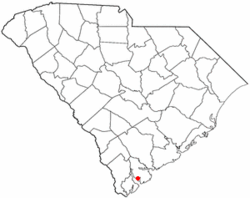
 Location of Parris Island, South Carolina | |
| Coordinates: 32°19′44″N 80°41′41″W / 32.32889°N 80.69472°W | |
| Country | United States |
| State | South Carolina |
| County | Beaufort |
| Area | |
| • Total | 19.6 sq mi (51 km2) |
| • Land | 12.2 sq mi (32 km2) |
| • Water | 7.4 sq mi (19 km2) |
| Population (2000) | |
| • Total | 4,841 |
| • Density | 250/sq mi (95/km2) |
| Time zone | UTC-5 (Eastern (EST)) |
| • Summer (DST) | UTC-4 (EDT) |
| ZIP codes | 29902, 29905 |
| Area code(s) | 843, 854 |
| FIPS code | 45-54850[1] |
Parris Island is a district of the city of Port Royal, South Carolina on an island of the same name. It became part of the city with the annexation of the Marine Corps Recruit Depot Parris Island on October 11, 2002. For statistical purposes, the United States Census Bureau previously defined Parris Island as a census-designated place (CDP) when it was an unincorporated area of Beaufort County. The population was 4,841 at the 2000 census. As defined by the U.S. Census Bureau, Parris Island is included within the Beaufort Urban Cluster and the larger Hilton Head Island–Beaufort Micropolitan Statistical Area.[2]
- ^ "U.S. Census website". United States Census Bureau. Retrieved January 31, 2008.
- ^ Population Estimates Boundary Changes, United States Census Bureau, 2007-07-01. Accessed 2008-11-06.