| Pasir Panjang Pillbox | |
|---|---|
| Part of World War II-era Defence of Singapore | |
| Singapore | |
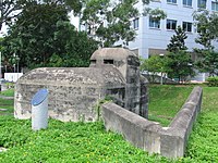
 Pasir Panjang Pillbox, here photographed in 2006. | |
| Coordinates | 1°17′20″N 103°46′41″E / 1.289°N 103.778167°E |
| Site information | |
| Controlled by | British military (former) |
| Open to the public | Yes (externally only; access inside the pillbox is not allowed) |
| Condition | Good |
| Site history | |
| Built | pre-WWII |
| Built by | British military |
| Materials | Concrete (reinforced) and steel |
| Battles/wars | Battle of Pasir Panjang |
| Events | Second World War |
| Garrison information | |
| Current commander | None |
| Past commanders | Unknown |
| Garrison | occupied by British military forces in Singapore (former) |
| Occupants | British military (former) |
Pasir Panjang Pillbox is a strengthened-concrete defensive structure from World War II, located in Pasir Panjang in the southwestern area of Singapore.
