Back مقاطعة باسيك (نيو جيرسي) Arabic Passeyik (dairə) Azerbaijani Passaic County, New Jersey BAR Пъсейик (окръг, Ню Джърси) Bulgarian পাসায়িক কাউন্টি, নিউ জার্সি BPY Passaic Gông (New Jersey) CDO Пассейик (гуо, Нью-Джерси) CE Passaic County CEB Passaic County Czech Passaic County, New Jersey Welsh
Passaic County | |
|---|---|
 | |
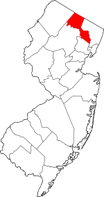
 Location within the U.S. state of New Jersey | |
 New Jersey's location within the U.S. | |
| Coordinates: 41°02′N 74°18′W / 41.03°N 74.30°W | |
| Country | |
| State | |
| Founded | February 7, 1837[3] |
| Named for | "Pasaeck", a Lenape word meaning "valley" |
| Seat | Paterson[4] |
| Largest municipality | Paterson (population) West Milford (area) |
| Government | |
| • Commissioner Director | Pat Lepore (D, term ends December 31, 2025) |
| Area | |
• Total | 198.39 sq mi (513.8 km2) |
| • Land | 186.01 sq mi (481.8 km2) |
| • Water | 12.38 sq mi (32.1 km2) 6.2% |
| Population (2020) | |
• Total | 524,118[1][2] |
| 513,395 | |
| Time zone | UTC−5 (Eastern) |
| • Summer (DST) | UTC−4 (EDT) |
| Congressional districts | 5th, 9th, 11th |
| Website | passaiccountynj |

Passaic County (/pəˈseɪ.ɪk/ pə-SAY-ik or locally /pəˈseɪk/ pə-SAYK) is a county in the U.S. state of New Jersey that is part of the New York metropolitan area. As of the 2020 United States census, the county was the state's eighth-most-populous county,[7] with a population of 524,118,[1][2] its highest decennial count ever and an increase of 22,892 (+4.6%) from the 2010 census count of 501,226,[8] which in turn reflected an increase of 12,177 (+2.5%) from the 489,049 counted in the 2000 census.[1]
The most populous place in Passaic County is Paterson, the county seat, with 159,732 residents at the 2020 Census, more than 30% of the county's population,[2] while West Milford covered 80.32 square miles (208.0 km2), the largest total area of any municipality and more than 40% of the county's area.[9] The county is part of the North Jersey region of the state.[10][11]
- ^ a b c d Cite error: The named reference
Census2020was invoked but never defined (see the help page). - ^ a b c Cite error: The named reference
LWD2020was invoked but never defined (see the help page). - ^ Cite error: The named reference
Storywas invoked but never defined (see the help page). - ^ New Jersey County Map, New Jersey Department of State. Accessed July 10, 2017.
- ^ Cite error: The named reference
CensusAreawas invoked but never defined (see the help page). - ^ Cite error: The named reference
PopEstwas invoked but never defined (see the help page). - ^ Table 1. New Jersey Counties and Most Populous Cities and Townships: 2020 and 2010 Censuses, New Jersey Department of Labor and Workforce Development. Accessed December 1, 2022.
- ^ Cite error: The named reference
Census2010was invoked but never defined (see the help page). - ^ Cite error: The named reference
CPH232was invoked but never defined (see the help page). - ^ Willis, David P. "'This is how wars start': Does Central Jersey include both Ocean and Union counties?", Asbury Park Press, February 20, 2023. Accessed March 31, 2024. "North Jersey is defined as Sussex, Warren, Morris, Passaic, Bergen, Essex and Hudson counties; South Jersey would be Burlington, Camden, Gloucester, Atlantic, Salem, Cumberland and Cape May counties. But for Central, things get a little tricky. It would include Hunterdon, Somerset, Union, Middlesex, Mercer, Monmouth, and Ocean counties."
- ^ "Regions: North, Central, South, Shore - Best of NJ", Best of NJ, Accessed May 30, 2024. "Northern Jersey consists of Bergen, Essex, Hudson, Morris, Passaic, Sussex, and Warren County."


