Back Pata (Eslovàquia) Catalan Pata (okres Galanta) Czech Pata (Slowakei) German Pata (distrikto Galanta) Esperanto Pata (Galanta) Spanish Pata (Galantako barrutia) Basque Pata (Slovaquie) French Vágpatta Hungarian Pata (Slovacchia) Italian Pata, Daerah Galanta Malay
Pata | |
|---|---|
Municipality | |
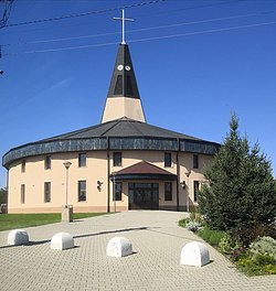
 Church of Nativity of Virgin Mary | |
Location of Pata in the Trnava Region | |
| Coordinates: 48°17′N 17°50′E / 48.283°N 17.833°E | |
| Country | Slovakia |
| Region | Trnava |
| District | Galanta |
| First mentioned | 1156 |
| Area | |
| • Total | 17.54[2] km2 (6.77[2] sq mi) |
| Elevation | 138[3] m (453[3] ft) |
| Population (2021) | |
| • Total | 3,241[1] |
| Time zone | UTC+1 (CET) |
| • Summer (DST) | UTC+2 (CEST) |
| Postal code | 925 53[3] |
| Area code | +421 31[3] |
| Car plate | GA |
| Website | www.obecpata.sk |
Pata (Hungarian: Vágpatta) is a village and municipality in Galanta District of the Trnava Region of south-west Slovakia. The village lies in central part of Danubian Lowland (in part called Danubian Upland) and in east–west part of Nitra Upland. The area consists of a mild upland and a shallow valley Jác. The Jarčie watercourse flows through the village. Nearby villages are Šoporňa, Báb, Pusté Sady, Šintava a Hájske. Pata lies 9 kilometres far from city of Sereď. Village is situated close to R1 expressway, which connect Trnava and Nitra.
- ^ "Počet obyvateľov podľa pohlavia - obce (ročne)". www.statistics.sk (in Slovak). Statistical Office of the Slovak Republic. 2022-03-31. Retrieved 2022-03-31.
- ^ a b "Hustota obyvateľstva - obce [om7014rr_ukaz: Rozloha (Štvorcový meter)]". www.statistics.sk (in Slovak). Statistical Office of the Slovak Republic. 2022-03-31. Retrieved 2022-03-31.
- ^ a b c d "Základná charakteristika". www.statistics.sk (in Slovak). Statistical Office of the Slovak Republic. 2015-04-17. Retrieved 2022-03-31.
- ^ a b "Hustota obyvateľstva - obce". www.statistics.sk (in Slovak). Statistical Office of the Slovak Republic. 2022-03-31. Retrieved 2022-03-31.

