Back نهر بينيفاذر ARZ Riu Pennefather Catalan Pennefather River CEB Pennefather River French Sungai Pennefather ID Pennefather Italian Pennefather Polish Pennefather River Swedish
| Pennefather | |
|---|---|
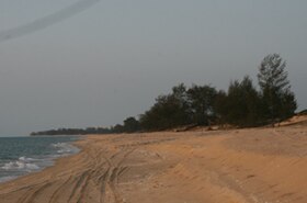
 Near Pennefather River mouth, in southwest Cape York Peninsula | |
Location of Pennefather River mouth in Queensland | |
| Etymology | In honour of Charles de Fonblanque Pennefather[1] |
| Location | |
| Country | Australia |
| State | Queensland |
| Region | Far North Queensland |
| Physical characteristics | |
| Source | |
| • location | Mapoon |
| • coordinates | 12°19′53″S 141°52′22″E / 12.33147°S 141.87289°E |
| • elevation | 20 m (66 ft) |
| Source confluence | Fish Creek and a series of unnamed waterways |
| • location | Port Musgrave Aggregation wetlands |
| • coordinates | 12°15′17″S 141°48′19″E / 12.25472°S 141.80528°E |
| • elevation | 1 m (3 ft 3 in) |
| Mouth | Gulf of Carpentaria |
• location | south of Mapoon |
• coordinates | 12°13′44″S 141°43′14″E / 12.22889°S 141.72056°E |
• elevation | 0 m (0 ft) |
| Length | 11 km (6.8 mi) |
| Basin size | 3,009 km2 (1,162 sq mi) |
| [2] | |
The Pennefather River is a river located on the western Cape York Peninsula in Far North Queensland, Australia.[1]
- ^ a b Cite error: The named reference
QPNwas invoked but never defined (see the help page). - ^ "Map of Pennefather River, QLD". Bonzle Digital Atlas of Australia. Retrieved 30 November 2015.
