Back Pennsauken CEB Pennsauken Township, New Jersey Welsh Pennsauken Township German Municipio de Pennsauken Spanish پنساوکن، نیوجرسی Persian Pennsauken, New Jersey HT Pennsauken Italian Пэннсаукэн Тауншип (Нью-Джерси) Kazakh Пэннсаукэн Тауншип (Нү-Жерси) Kirghiz Pennsauken Dutch
Pennsauken Township, New Jersey | |
|---|---|
| Motto(s): A Great Place to Grow, Dream and Prosper! | |
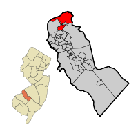
 Location of Pennsauken Township in Camden County highlighted in red (right). Inset map: Location of Camden County in New Jersey highlighted in orange (left). | |
 | |
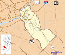
Location in Camden County Location in New Jersey | |
| Coordinates: 39°58′06″N 75°03′29″W / 39.968392°N 75.057942°W[1][2] | |
| Country | |
| State | |
| County | Camden |
| Incorporated | February 18, 1892 |
| Government | |
| • Type | Township |
| • Body | Township Committee |
| • Mayor | Vince Martinez (D, term ends December 31, 2023)[3][4] |
| • Administrator | Tim Killion[5] |
| • Municipal clerk | Pam Scott-Forman [6] |
| Area | |
| • Total | 12.13 sq mi (31.41 km2) |
| • Land | 10.48 sq mi (27.14 km2) |
| • Water | 1.65 sq mi (4.27 km2) 13.59% |
| • Rank | 189th of 565 in state 5th of 37 in county[1] |
| Elevation | 89 ft (27 m) |
| Population | |
| • Total | 37,074 |
| • Estimate | 37,288 |
| • Rank | 66th of 565 in state 5th of 37 in county[12] |
| • Density | 3,537.9/sq mi (1,366.0/km2) |
| • Rank | 190th of 565 in state 23rd of 37 in county[12] |
| Time zone | UTC−05:00 (Eastern (EST)) |
| • Summer (DST) | UTC−04:00 (Eastern (EDT)) |
| ZIP Codes | |
| Area code[15] | 856 |
| FIPS code | 3400757660[1][16][17] |
| GNIS feature ID | 0882157[1][18] |
| Website | www |
Pennsauken Township is a township in Camden County, in the Philadelphia Metropolitan Area in the U.S. state of New Jersey, and it is located outside of Philadelphia, Pennsylvania, which it borders directly on the Delaware River. As of the 2020 United States census, the township's population was 37,074,[9][10] an increase of 1,189 (+3.3%) from the 2010 census count of 35,885,[19][20] which in turn increased by 148 (+0.4%) from the 35,737 counted in the 2000 census.[21]
The township is part of the South Jersey region of the state.
- ^ a b c d e 2019 Census Gazetteer Files: New Jersey Places, United States Census Bureau. Accessed July 1, 2020.
- ^ US Gazetteer files: 2010, 2000, and 1990, United States Census Bureau. Accessed September 4, 2014.
- ^ Cite error: The named reference
Committeewas invoked but never defined (see the help page). - ^ 2023 New Jersey Mayors Directory, New Jersey Department of Community Affairs, updated February 8, 2023. Accessed February 10, 2023.
- ^ Administration, Pennsauken Township. Accessed June 8, 2023.
- ^ Municipal Clerk's Office, Pennsauken Township. Accessed June 8, 2023.
- ^ Cite error: The named reference
DataBookwas invoked but never defined (see the help page). - ^ U.S. Geological Survey Geographic Names Information System: Township of Pennsauken, Geographic Names Information System. Accessed March 8, 2013.
- ^ a b c Cite error: The named reference
Census2020was invoked but never defined (see the help page). - ^ a b Cite error: The named reference
LWD2020was invoked but never defined (see the help page). - ^ Cite error: The named reference
PopEstwas invoked but never defined (see the help page). - ^ a b Population Density by County and Municipality: New Jersey, 2020 and 2021, New Jersey Department of Labor and Workforce Development. Accessed March 1, 2023.
- ^ Look Up a ZIP Code for Pennsauken, NJ, United States Postal Service. Accessed July 24, 2012.
- ^ Zip Codes, State of New Jersey. Accessed October 15, 2013.
- ^ Area Code Lookup - NPA NXX for Pennsauken, NJ, Area-Codes.com. Accessed October 15, 2013.
- ^ U.S. Census website, United States Census Bureau. Accessed September 4, 2014.
- ^ Geographic codes for New Jersey, Missouri Census Data Center. Accessed April 1, 2022.
- ^ US Board on Geographic Names, United States Geological Survey. Accessed September 4, 2014.
- ^ Cite error: The named reference
Census2010was invoked but never defined (see the help page). - ^ Cite error: The named reference
LWD2010was invoked but never defined (see the help page). - ^ Table 7. Population for the Counties and Municipalities in New Jersey: 1990, 2000 and 2010, New Jersey Department of Labor and Workforce Development, February 2011. Accessed May 1, 2023.


