Back مقاطعة بينوبسكوت (مين) Arabic Penobscot County, Maine BAR Пънобскот (окръг, Мейн) Bulgarian পেনোবস্কট কাউন্টি, মেইন BPY Penobscot Gông (Maine) CDO Пенобскот (гуо, Мэн) CE Penobscot County CEB Penobscot County, Maine Welsh Penobscot County German Condado de Penobscot Spanish
Penobscot County | |
|---|---|
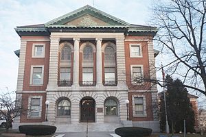
 Penobscot County Courthouse | |
 Location within the U.S. state of Maine | |
 Maine's location within the U.S. | |
| Coordinates: 45°24′N 68°38′W / 45.40°N 68.63°W | |
| Country | |
| State | |
| Founded | 1816 |
| Named for | Penobscot tribe |
| Seat | Bangor |
| Largest city | Bangor |
| Area | |
| • Total | 3,557 sq mi (9,210 km2) |
| • Land | 3,397 sq mi (8,800 km2) |
| • Water | 160 sq mi (400 km2) 4.5% |
| Population (2020) | |
| • Total | 152,199 |
| • Density | 45/sq mi (17/km2) |
| Time zone | UTC−5 (Eastern) |
| • Summer (DST) | UTC−4 (EDT) |
| Congressional district | 2nd |
| Website | www.penobscot-county.net |
Penobscot County is a county in the U.S. state of Maine, named for the Penobscot people in Wabanakik.[1] As of the 2020 census, the population was 152,199,[2] making it the third-most-populous county in Maine. Its county seat is Bangor.[3] The county was established on February 15, 1816, from part of Hancock County when the area was still part of Massachusetts. Penobscot County is home to the University of Maine.
Penobscot County comprises the Bangor, ME Metropolitan Statistical Area.
- ^ Girouard, Maria (December 3, 2020). "Acknowledging the Land". Wabanaki REACH.
- ^ "Census - Geography Profile: Penobscot County, Maine". United States Census Bureau. Retrieved November 21, 2021.
- ^ "Find a County". National Association of Counties. Retrieved June 7, 2011.