Back بينرين Arabic بينرين ARZ پنرین، کورنوال AZB Pennrynn Breton Penryn (lungsod sa Hiniusang Gingharian, Inglatera, Cornwall, lat 50,17, long -5,10) CEB Penryn, Cernyw Welsh Penryn (Cornwall) German Penryn (Cornualles) Spanish Penryn (Kornualles) Basque پنرین، کورنوال Persian
Penryn
| |
|---|---|
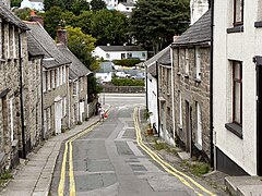
 St Gluvias Street, Penryn | |
Location within Cornwall | |
| Population | 6,812 (Census 2011)[1] |
| OS grid reference | SW782345 |
| Civil parish |
|
| Unitary authority | |
| Ceremonial county | |
| Region | |
| Country | England |
| Sovereign state | United Kingdom |
| Post town | PENRYN |
| Postcode district | TR10 |
| Dialling code | 01326 |
| Police | Devon and Cornwall |
| Fire | Cornwall |
| Ambulance | South Western |
| UK Parliament | |
Penryn (/pɛnˈrɪn/;[2] Cornish: Pennrynn,[3] meaning 'promontory') is a civil parish and town in west Cornwall, England, United Kingdom. It is on the Penryn River about 1 mile (1.6 km) northwest of Falmouth.[4] The population was 7,166 in the 2001 census and had been reduced to 6,812 in the 2011 census, a drop of more than 300 people across the ten-year time gap.[5] There are two electoral wards covering Penryn: 'Penryn East and Mylor' and 'Penryn West'. The total population of both wards in the 2011 census was 9,790.[6][7]
Though now the town is overshadowed by the larger nearby town of Falmouth, Penryn was once an important harbour in its own right, lading granite and tin to be shipped to other parts of the country and world during the medieval period.
- ^ "Local statistics – Office for National Statistics". neighbourhood.statistics.gov.uk. Archived from the original on 3 March 2016. Retrieved 29 April 2018.
- ^ BBC Pronouncing Dictionary of British Names; new ed.; edited & transcribed by G. E. Pointon. Oxford: Oxford University Press, 1983; p. 191
- ^ "List of Place-names agreed by the MAGA Signage Panel" (PDF). Cornish Language Partnership. May 2014. Archived from the original (PDF) on 29 July 2014. Retrieved 11 January 2015.
- ^ Ordnance Survey: Landranger map sheet 204 Truro & Falmouth ISBN 978-0-319-23149-4
- ^ "Parish population 2011". Archived from the original on 8 February 2015. Retrieved 10 February 2015.
- ^ "Ward population for Penryn East & Mylor 2011". Archived from the original on 10 February 2015. Retrieved 10 February 2015.
- ^ "Ward population for Penryn West 2011". Archived from the original on 4 March 2016. Retrieved 10 February 2015.
