Back Peterborough (lungsod sa Ostralya, State of South Australia, Peterborough, lat -32,97, long 138,84) CEB Peterborough (South Australia) German پیتربورو، استرالیای جنوبی Persian Peterborough (Australie-Méridionale) French Peterborough (Australia Meridionale) Italian Peterborough (Australia Południowa) Polish Peterborough, South Australia Swedish
| Peterborough South Australia | |||||||||||||||
|---|---|---|---|---|---|---|---|---|---|---|---|---|---|---|---|
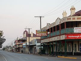
 Main street of Peterborough | |||||||||||||||
| Coordinates | 32°58′S 138°50′E / 32.967°S 138.833°E | ||||||||||||||
| Population | 1,428 (UCL 2021)[1] | ||||||||||||||
| Established | 1869 | ||||||||||||||
| Postcode(s) | 5422 | ||||||||||||||
| Elevation | 420 m (1,378 ft) | ||||||||||||||
| Location |
| ||||||||||||||
| LGA(s) | District Council of Peterborough | ||||||||||||||
| State electorate(s) | Stuart | ||||||||||||||
| Federal division(s) | Division of Grey | ||||||||||||||
| Website | Peterborough | ||||||||||||||
| |||||||||||||||
Peterborough is a town in the mid north of South Australia, in wheat country, just off the Barrier Highway. It was originally named Petersburg after the landowner, Peter Doecke, who sold land to create the town. It was one of 69 places in South Australia renamed in 1917 due to anti-German sentiments during World War I.
- ^ Australian Bureau of Statistics (28 June 2022). "Peterborough (urban centre and locality)". Australian Census 2021.
