Back مقاطعة فيليبس (أركنساس) Arabic Phillips County, Arkansas BAR Филипс (окръг, Арканзас) Bulgarian ফিলিপ্স কাউন্টি, আরকান্সাস BPY Phillips Gông (Arkansas) CDO Филлипс (гуо, Арканзас) CE Phillips County (kondado sa Tinipong Bansa, Arkansas) CEB Phillips County, Arkansas Welsh Phillips County (Arkansas) German Κομητεία Φίλιπς (Άρκανσο) Greek
Phillips County | |
|---|---|
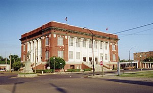
 Phillips County courthouse in Helena-West Helena | |
 Location within the U.S. state of Arkansas | |
 Arkansas's location within the U.S. | |
| Coordinates: 34°23′25″N 90°52′11″W / 34.390277777778°N 90.869722222222°W | |
| Country | |
| State | |
| Founded | May 1, 1820 |
| Named for | Sylvanus Phillips |
| Seat | Helena-West Helena |
| Largest city | Helena-West Helena |
| Area | |
| • Total | 727 sq mi (1,880 km2) |
| • Land | 696 sq mi (1,800 km2) |
| • Water | 32 sq mi (80 km2) 4.4% |
| Population (2020) | |
| • Total | 16,568 |
| • Estimate (2021) | 15,906 |
| • Density | 23/sq mi (8.8/km2) |
| Time zone | UTC−6 (Central) |
| • Summer (DST) | UTC−5 (CDT) |
| Congressional district | 1st |
| Website | phillipscounty |
Phillips County is a county located in the eastern part of the U.S. state of Arkansas, in what is known as the Arkansas Delta along the Mississippi River. As of the 2020 census, the population was 16,568.[1] The county seat is Helena–West Helena.[2]
Phillips County is Arkansas's seventh (7th) county, formed on May 1, 1820. It was named for Sylvanus Phillips, the area's first-known white or European-American settler; he was elected as representative to the first Territorial Legislature of the Arkansas Territory. This fertile lowland area was developed for cotton plantations in the antebellum area and is still largely rural and agricultural.[citation needed]
The Helena-West Helena, AR Micropolitan Statistical Area includes all of Phillips County.
- ^ "U.S Census Bureau QuickFacts: Phillips County, Arkansas". Retrieved November 29, 2022.
- ^ "Find a County". National Association of Counties. Retrieved June 7, 2011.