Back مقاطعة بيكاواي (أوهايو) Arabic پیکاوای بؤلگهسی، اوهایو AZB Pickaway County, Ohio BAR Пикъуей (окръг, Охайо) Bulgarian পিকএৱে কাউন্টি, ওহাইও BPY Pickaway Gông (Ohio) CDO Pickaway County CEB Pickaway County, Ohio Welsh Pickaway County Danish Pickaway County German
Pickaway County | |
|---|---|
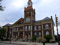
 Pickaway County Courthouse | |
 Location within the U.S. state of Ohio | |
 Ohio's location within the U.S. | |
| Coordinates: 39°38′N 83°02′W / 39.64°N 83.03°W | |
| Country | |
| State | |
| Founded | March 1, 1810[1] |
| Named for | Pekowi band |
| Seat | Circleville |
| Largest city | Circleville |
| Area | |
| • Total | 507 sq mi (1,310 km2) |
| • Land | 501.32 sq mi (1,298.4 km2) |
| • Water | 5.23 sq mi (13.5 km2) 1.0% |
| Population (2020) | |
| • Total | 58,539 |
| • Density | 120/sq mi (50/km2) |
| Time zone | UTC−5 (Eastern) |
| • Summer (DST) | UTC−4 (EDT) |
| Congressional district | 2nd |
| Website | www |
Pickaway County is a county in the U.S. state of Ohio. As of the 2020 census, the population was 58,539.[2] Its county seat is Circleville.[3] Its name derives from the Pekowi band of Shawnee Indians, who inhabited the area. (See List of Ohio county name etymologies.)
Pickaway County is part of the Columbus, OH Metropolitan Statistical Area.
- ^ "Ohio County Profiles: Pickaway County" (PDF). Ohio Department of Development. Archived from the original (PDF) on June 21, 2007. Retrieved June 10, 2019.
- ^ 2020 census
- ^ "Find a County". National Association of Counties. Retrieved June 7, 2011.

