Back جبل پيكو دو فوجو ARZ Фогу (вулкан) Byelorussian Fogo Catalan Pico (tumoy sa bukid) CEB Pico do Fogo Czech Pico do Fogo German Pico do Fogo Spanish Fogo vulkaan Estonian Pico do Fogo Basque پیکو دو فوگو Persian
| Pico de Fogo | |
|---|---|
 | |
| Highest point | |
| Elevation | 2,829 m (9,281 ft)[1][2] |
| Prominence | 2,829 m (9,281 ft) Ranked 120th |
| Listing | Country high point Ultra List of mountains in Cape Verde |
| Coordinates | 14°57′00″N 24°20′30″W / 14.95000°N 24.34167°W[1] |
| Geography | |
| Geology | |
| Mountain type | Sommian-Stratovolcano |
| Last eruption | November 2014 to February 2015 |
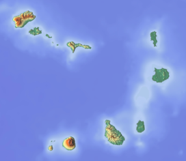
Pico do Fogo (Portuguese: [ˈpiku du ˈfoɡu]; lit. 'Peak of Fire') is an active stratovolcano located on the island of Fogo, Cape Verde, rising to 2,829 metres (9,281 ft) above sea level.[2] The main cone last erupted in 1680, causing mass emigration from the island.[3] A subsidiary vent erupted in 1995. The only deadly eruption was in 1847 when earthquakes killed several people.
Fogo, which means "fire" in Portuguese, is a hotspot volcanic island.[4] Its most recent eruptions occurred in 1951, 1995 and 2014. It is the youngest and most active volcano in the Cape Verde Islands, a short chain of volcanic islands that generally are younger at the western end, formed as the African Plate moved towards the east over the hotspot.[5]
Fogo consists of a single volcano, so the island is nearly round and about 25 kilometers (16 mi) in diameter.[6] The large summit caldera (about 10 kilometers in the north–south direction and 7 kilometers in the east–west direction) is not located in the center of the island, but rather towards its northeastern corner. The caldera is bounded by steep near-vertical fault scarps on the north, west, and south sides but is breached to the east where lava can flow to the coast.[7] North-northeast-trending eruptive fissures opened along the western flank of Pico, which formed inside the caldera between about 1500 and 1760.[5] The last eruption from the top was in 1769. The current topography of Fogo, with the caldera open to the sea on the east side, results from the sliding of the east flank of the volcano towards the ocean.[5]
The mountain's slopes are used to grow coffee, while its lava is used as building material.[citation needed] Near its peak is a caldera and a small village, Chã das Caldeiras, is inside this caldera. The crater rim, which reaches 2,700 m elevation, is known as Bordeira.
- ^ a b "Fogo". Global Volcanism Program. Smithsonian Institution. Retrieved 2018-10-11.
- ^ a b Cabo Verde, Statistical Yearbook 2015, Instituto Nacional de Estatística, p. 25
- ^ Cite error: The named reference
jenkinswas invoked but never defined (see the help page). - ^ Carracedo, Juan Carlos; Troll, Valentin R. (2021-01-01). "North-East Atlantic Islands: The Macaronesian Archipelagos". Encyclopedia of Geology. pp. 674–699. doi:10.1016/B978-0-08-102908-4.00027-8. ISBN 9780081029091. S2CID 226588940.
- ^ a b c Cite error: The named reference
hvo_1995was invoked but never defined (see the help page). - ^ Carracedo, Juan-Carlos; Perez-Torrado, Francisco J.; Rodriguez-Gonzalez, Alejandro; Paris, Raphaël; Troll, Valentin R.; Barker, Abigail K. (July 2015). "Volcanic and structural evolution of Pico do Fogo, Cape Verde". Geology Today. 31 (4): 146–152. Bibcode:2015GeolT..31..146C. doi:10.1111/gto.12101. S2CID 128995452.
- ^ Carracedo, Juan-Carlos; Perez-Torrado, Francisco J.; Rodriguez-Gonzalez, Alejandro; Paris, Raphaël; Troll, Valentin R.; Barker, Abigail K. (2015). "Volcanic and structural evolution of Pico do Fogo, Cape Verde". Geology Today. 31 (4): 146–152. Bibcode:2015GeolT..31..146C. doi:10.1111/gto.12101. ISSN 1365-2451. S2CID 128995452.
