Pilsen, Kansas | |
|---|---|
 | |
| Coordinates: 38°28′17″N 97°02′25″W / 38.4714024°N 97.0402972°W[1] | |
| Country | United States |
| State | Kansas |
| County | Marion |
| Township | Clark, Clear Creek |
| Founded | 1874 |
| Named for | Plzeň |
| Elevation | 1,434 ft (437 m) |
| Population | |
| • Total | 65 |
| Time zone | UTC-6 (CST) |
| • Summer (DST) | UTC-5 (CDT) |
| ZIP code | 66861 |
| Area code | 620 |
| FIPS code | 20-55875 |
| GNIS ID | 477246[1] |
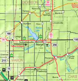
Pilsen is a census-designated place (CDP) in Marion County, Kansas, United States.[1] As of the 2020 census, the population was 65.[2] The community is named after the city Plzeň (German: Pilsen) in Czech Republic, formerly Bohemia.[3] It is located north of Marion and west of Lincolnville at the intersection of Remington Road and 275th Street.
- ^ a b c d U.S. Geological Survey Geographic Names Information System: Pilsen, Kansas
- ^ a b "Profile of Pilsen, Kansas (CDP) in 2020". United States Census Bureau. Archived from the original on November 11, 2021. Retrieved November 11, 2021.
- ^ Marion County Kansas, Past and Present; Sondra Van Meter; 1972.


