Back Pincher Creek ATJ Pincher Creek (lungsod) CEB Pincher Creek German Pincher Creek French Pincher Creek Italian Pincher Creek Kurdish Pincher Creek Dutch Pincher Creek Portuguese Пинчер Крик (Алберта) Serbian Pincher Creek Swedish
Pincher Creek | |
|---|---|
Town | |
| Town of Pincher Creek | |
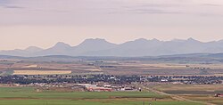
 Pincher Creek as seen from the North, with the Canadian Rockies in the background | |
Location of Pincher Creek in Alberta | |
| Coordinates: 49°29′10″N 113°57′00″W / 49.48611°N 113.95000°W | |
| Country | Canada |
| Province | Alberta |
| Region | Southern Alberta |
| Census division | 3 |
| Municipal district | Municipal District of Pincher Creek No. 9 |
| Incorporated[1] | |
| • Village | August 18, 1898 |
| • Town | May 12, 1906 |
| Government | |
| • Mayor | Don Anderberg |
| • Governing body | Pincher Creek Town Council |
| Area (2021)[3] | |
| • Land | 9.87 km2 (3.81 sq mi) |
| Elevation | 1,130 m (3,710 ft) |
| Population | |
| • Total | 3,622 |
| • Density | 367.1/km2 (951/sq mi) |
| Time zone | UTC−7 (MST) |
| • Summer (DST) | UTC−6 (MDT) |
| Postal code | |
| Area code | 403 / 587 |
| Highways | |
| Waterways | Oldman River Reservoir |
| Website | www |
Pincher Creek is a town in southern Alberta, Canada. It is located immediately east of the Canadian Rockies, 101 km (63 mi) west of Lethbridge and 210 km (130 mi) south of Calgary.
- ^ "Location and History Profile: Town of Pincher Creek" (PDF). Alberta Municipal Affairs. October 7, 2016. p. 484. Archived (PDF) from the original on September 25, 2016. Retrieved October 13, 2016.
- ^ "Municipal Officials Search". Alberta Municipal Affairs. May 9, 2019. Retrieved October 1, 2021.
- ^ a b Cite error: The named reference
2021censuswas invoked but never defined (see the help page). - ^ "Alberta Private Sewage Systems 2009 Standard of Practice Handbook: Appendix A.3 Alberta Design Data (A.3.A. Alberta Climate Design Data by Town)" (PDF) (PDF). Safety Codes Council. January 2012. pp. 212–215 (PDF pages 226–229). Archived (PDF) from the original on October 16, 2013. Retrieved October 9, 2013.
- ^ "Population and dwelling counts: Canada and population centres". Statistics Canada. February 9, 2022. Retrieved February 13, 2022.

