Back بوينت كوك Arabic Point Cook (bahin nga lungsod) CEB پوینت کوک (ویکتوریا) Persian Point Cook (Victoria) NB Point Cook Swedish 库克角 Chinese
| Point Cook Melbourne, Victoria | |||||||||||||||
|---|---|---|---|---|---|---|---|---|---|---|---|---|---|---|---|
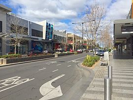
 Main Street, Point Cook | |||||||||||||||
 | |||||||||||||||
| Coordinates | 37°54′32″S 144°45′07″E / 37.909°S 144.752°E | ||||||||||||||
| Population | 66,781 (2021 census)[1] | ||||||||||||||
| • Density | 7,180/km2 (18,600/sq mi) | ||||||||||||||
| Postcode(s) | 3030 | ||||||||||||||
| Elevation | 12 m (39 ft) | ||||||||||||||
| Area | 9.3 km2 (3.6 sq mi) | ||||||||||||||
| Location | 22 km (14 mi) from Melbourne | ||||||||||||||
| LGA(s) | City of Wyndham | ||||||||||||||
| State electorate(s) | Point Cook | ||||||||||||||
| Federal division(s) | |||||||||||||||
| |||||||||||||||
Point Cook is a suburb in Melbourne, Victoria, Australia, 22 km (14 mi) south-west of Melbourne's Central Business District, located within the City of Wyndham local government area. Point Cook recorded a population of 66,781 at the 2021 census.[1]
Point Cook is the home of RAAF Base Point Cook, the birthplace of the Royal Australian Air Force, and is the current home of the RAAF Museum. Point Cook is also home to many playgrounds and parks/public spaces. The wetlands of the Point Cook Coastal Park form part of the Cheetham and Altona Important Bird Area.[2]
The major development of the suburb began in the late 1990s. The population of Point Cook has been growing rapidly since 2001 when the population was 1,737. At the 2016 census, Point Cook's population was 49,929,[3] and had risen to 66,718 by 2021.[4]
- ^ a b Australian Bureau of Statistics (28 June 2022). "Point Cook (Suburbs and Localities)". 2021 Census QuickStats. Retrieved 22 July 2022.
- ^ "IBA: Cheetham and Altona". Birdata. Birds Australia. Retrieved 15 June 2011.
- ^ Australian Bureau of Statistics (27 June 2017). "Point Cook (State Suburb)". 2016 Census QuickStats. Retrieved 31 August 2017.
- ^ "City of Wyndham Community Profile: Point Cook". .id Consulting Pty Ltd. Retrieved 27 July 2019.
