This article needs additional citations for verification. (September 2018) |
| Point Sturt South Australia | |||||||||||||||
|---|---|---|---|---|---|---|---|---|---|---|---|---|---|---|---|
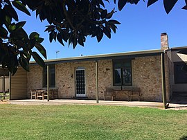
 Original stone settlers cottage at Nanda Farm, Point Sturt (c. 1855) | |||||||||||||||
| Coordinates | 35°29′32″S 138°58′07″E / 35.492196°S 138.96868°E[1] | ||||||||||||||
| Population | 69 (shared with part of Milang) (2016 census)[2][a] | ||||||||||||||
| Established | 1850s (private sub-division) 31 August 2000 (locality)[1] | ||||||||||||||
| Postcode(s) | 5256[3] | ||||||||||||||
| Time zone | ACST (UTC+9:30) | ||||||||||||||
| • Summer (DST) | ACDT (UTC+10:30) | ||||||||||||||
| Location | |||||||||||||||
| LGA(s) | Alexandrina Council[1] | ||||||||||||||
| Region | Fleurieu and Kangaroo Island[4] | ||||||||||||||
| County | Hindmarsh[1] | ||||||||||||||
| State electorate(s) | Hammond[5] | ||||||||||||||
| Federal division(s) | Mayo[6] | ||||||||||||||
| |||||||||||||||
| Footnotes | Locations[1][3] Adjoining localities[1] | ||||||||||||||
Point Sturt is a locality in the Australian state of South Australia located on the Sturt Peninsula on the west side of Lake Alexandrina about 71 kilometres (44 mi) south-east of the state capital of Adelaide and about 17 kilometres (11 mi) east of the municipal seat of Goolwa.[1][3]
It is made up of rural living land holdings, primary production and grazing land. The beginning of Point Sturt Road is about 4 km from Clayton Bay and 9 km south of Milang, South Australia. At the end of Point Sturt road there are views across Lake Alexandrina to Raukkan.[7]
- ^ a b c d e f g h "Search result for "Point Sturt, LOCB" with the following datasets selected – "Suburbs and Localities", "Counties", "Local Government Areas", "SA Government Regions" and "Gazetteer"". Location SA Map Viewer. South Australian government. Retrieved 16 September 2018.
- ^ a b Australian Bureau of Statistics (27 June 2017). "Point Sturt (state suburb)". 2016 Census QuickStats. Retrieved 17 September 2018.
- ^ a b c "Postcode for Point Sturt, South Australia". postcodes-australia.com. Retrieved 17 September 2018.
- ^ "Fleurieu Kangaroo Island SA Government region" (PDF). The Government of South Australia. Retrieved 17 April 2017.
- ^ Hammond (Map). Electoral District Boundaries Commission. 2016. Retrieved 17 September 2018.
- ^ "Federal electoral division of Mayo, boundary gazetted 16 December 2011" (PDF). Australian Electoral Commission. Retrieved 25 January 2018.
- ^ "Streetview from the end of Point Sturt" (Map). Google Maps. Retrieved 22 December 2018.
Cite error: There are <ref group=lower-alpha> tags or {{efn}} templates on this page, but the references will not show without a {{reflist|group=lower-alpha}} template or {{notelist}} template (see the help page).

