Back Pontiese gebergte Afrikaans جبال بونتيك Arabic Montes Pónticos AST Pont dağları Azerbaijani Понт тауҙары Bashkir Понтийски планини Bulgarian পন্টিক পর্বতমালা Bengali/Bangla Muntanyes Pòntiques Catalan Doğukaradeniz Dağları CEB Pontské hory Czech
| Pontic Mountains | |
|---|---|
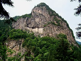
 Sumela Monastery on the Pontic Mountains | |
| Highest point | |
| Peak | Mt. Kaçkar |
| Elevation | 3,937 m (12,917 ft) |
| Coordinates | 40°50′N 41°09′E / 40.833°N 41.150°E |
| Dimensions | |
| Length | 1,000 km (620 mi) |
| Geography | |
 | |
| Countries | Turkey and Georgia |
| Range coordinates | 40°30′N 40°30′E / 40.500°N 40.500°E |
The Pontic Mountains or Pontic Alps (Turkish: Kuzey Anadolu Dağları, meaning North Anatolian Mountains) form a mountain range in northern Anatolia, Turkey. They are also known as the Parhar Mountains in the local Turkish and Pontic Greek languages. The term Parhar originates from a Hittite word meaning "high" or "summit".[1] In ancient Greek, the mountains were called the Paryadres[2] or Parihedri Mountains.[3]
- ^ Karadeniz Ansiklopedik Sözlük Archived 2008-05-13 at the Wayback Machine. See the "Parhar" (plateau) and "Parhal" (village) articles.
- ^ Strabo. "Chapter XI". Geographica (35 BC – 23 AD). p. xii.4.
- ^ Pliny the Elder. "Chapter VI". Naturalis Historia (77–79 AD). p. iix.25.