Back Портал:Район на Санфранциския залив Bulgarian Portail:Région de la baie de San Francisco French
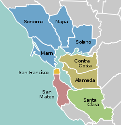
The San Francisco Bay Area Portal  The San Francisco Bay Area (referred to locally as the Bay Area) is a populous region surrounding the San Francisco and San Pablo estuaries in Northern California. The region encompasses the major cities and metropolitan areas of San Jose, San Francisco, and Oakland, along with smaller urban and rural areas. The Bay Area's nine counties are Alameda, Contra Costa, Marin, Napa, San Francisco, San Mateo, Santa Clara, Solano, and Sonoma. Home to approximately 7.68 million people, the nine-county Bay Area contains many cities, towns, airports, and associated regional, state, and national parks, connected by a network of roads, highways, railroads, bridges, tunnels, and commuter rail. The combined statistical area of the region is the second-largest in California (after the Greater Los Angeles area), the fifth-largest in the United States, and the 43rd-largest urban area in the world with 8.80 million people. The Bay Area has the second-most Fortune 500 companies in the United States, after the New York metropolitan area, and is known for its natural beauty, liberal politics, entrepreneurship, and diversity. The area ranks second in highest density of college graduates, after the Washington, D.C. metropolitan area and performs above the state median household income in the 2010 census; it includes the five highest California counties by per capita income and two of the top 25 wealthiest counties in the United States. Based on a 2013 population report from the California Department of Finance, the Bay Area is the only region in California where the rate of people migrating in from other areas in the United States is greater than the rate of those leaving the region, led by Alameda and Contra Costa counties. (more...) Selected article Today, People's Park is a free public park. Although open to all, it is mainly a daytime sanctuary for Berkeley's large homeless population who, along with others, receive meals from East Bay Food Not Bombs. Public toilets are available, and the park offers demonstration gardens, including organic community gardening beds and areas landscaped with California native plants, all of which were created by volunteer gardeners. Students use the basketball courts. A wider audience is attracted by occasional rallies, concerts, and hip-hop events conducted at the People's Stage, a wooden bandstand designed and built on the western end of the park by volunteers organized by the People's Park Council. Nearby residents, and those who try to use the park for recreation, sometimes experience conflict with the more aggressive homeless people. The local Southside neighborhood was the scene of a major confrontation between student protesters and police in May 1969. A mural near the park, painted by Berkeley artist O'Brien Thiele and lawyer/artist Osha Neumann, depicts the shooting of James Rector, a student who died from shotgun wounds inflicted by the police on May 15, 1969. (more...) Selected biography He developed more than 800 strains and varieties of plants over his 55-year career. Burbank's varied creations included fruits, flowers, grains, grasses, and vegetables. He developed a spineless cactus (useful for cattle-feed) and the plumcot. He moved to Santa Rosa, California in 1875, and purchased a 4-acre (16,000 m2) plot of land, and established a greenhouse, nursery, and experimental fields that he used to conduct crossbreeding experiments on plants, inspired by Charles Darwin's The Variation of Animals and Plants under Domestication. (This site is now open to the public as a city park, Luther Burbank Home and Gardens.) Later he purchased an 18-acre (7.3 ha) plot of land in the nearby town of Sebastopol, called Gold Ridge Farm. (more...) Selected city The city is one of the major cities that make up the Silicon Valley located in the San Francisco Bay Area. It is the seventh most populous city in the San Francisco Bay Area. Sunnyvale is bordered by portions of San Jose to the north, Moffett Federal Airfield to the northwest, Mountain View to the west, Los Altos to the southwest, Cupertino to the south, and Santa Clara to the east. It lies along the historic El Camino Real and Highway 101. As part of the Silicon Valley, high-tech companies such as Juniper Networks, Fortinet, AMD, NetApp, Spansion, Yahoo!, AppliedMicro and Ariba are headquartered there. Sunnyvale is also home to several aerospace/defense companies; Lockheed Martin has a major facility in Sunnyvale, and Honeywell, Northrop Grumman Electronic Systems - Marine Systems (formerly Joshua Hendy Iron Works), Finisar, and Spirent also have offices in Sunnyvale. Sunnyvale was also the home to Onizuka Air Force Station, where its memorial building was locally known as the Blue Cube. The base, named for the deceased Space Shuttle Challenger astronaut Ellison Onizuka, was an artificial satellite control facility of the United States armed forces until August 2010. (more...) Selected image
The Bay Area by year2018
    
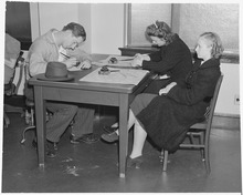
Selected historical imageDid you know...
Previous Did you know...
July - September 2010 Selected periodic event The Luther Burbank Rose Parade and Festival is an annual festival held in Santa Rosa celebrating the work of Luther Burbank, and centered on the Luther Burbank Home and Gardens (pictured). It began in 1894, and today has a budget of $100,000, with up to 250,000 attending. Quote
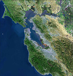
Selected multimedia fileBay Area regions, geographic features and protected areasRelated PortalsWikiProject
Things you can do *Write an article on a Bay Area-related subject Selected panoramaSan Francisco Bay Area categoriesBay Area | San Francisco Bay | San Francisco | San Jose | Oakland | Cities | Census-designated places | Historic Places | National Landmarks | Counties: Alameda | Contra Costa | Marin | Napa | San Mateo | Santa Clara | Solano | Sonoma
Architecture | Attractions | Books | Culture | Economy | Education | Environment | Events & Festivals | Geography | Government | History | Landmarks | Law | Mass media | Military | Music | Organizations | Parks | People | Politics | Science | Sports | Transport
Full category tree
Select [►] to view the full category tree.
Associated WikimediaThe following Wikimedia Foundation sister projects provide more on this subject:
Discover Wikipedia using portals |


