Highway 140 | ||||
|---|---|---|---|---|
| Ruta 140 | ||||
| Route information | ||||
| Maintained by Puerto Rico DTPW | ||||
| Length | 69.9 km[1] (43.4 mi) | |||
| Existed | 1953[2]–present | |||
| Major junctions | ||||
| South end | ||||
| ||||
| North end | ||||
| Location | ||||
| Country | United States | |||
| Territory | Puerto Rico | |||
| Municipalities | Jayuya, Utuado, Ciales, Florida, Barceloneta | |||
| Highway system | ||||
| ||||


Puerto Rico Highway 140 (PR-140) is a road that travels from Jayuya, Puerto Rico to Barceloneta, passing through Utuado, Ciales and Florida.[3] This highway begins at PR-143 in Pica barrio and ends at PR-2 in Florida Afuera barrio.[4]
- Puerto Rico Highway 140 by municipality
-
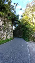 Heading north in Frontón, Ciales
 -
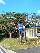 Northbound sign in Florida Afuera, Barceloneta


- ^ Cite error: The named reference
googlewas invoked but never defined (see the help page). - ^ "Jayuya, Memoria Núm. 68" (PDF). Puerto Rico Planning Board (in Spanish). 1955. Retrieved 4 August 2020.
- ^ National Geographic Maps (2011). Puerto Rico (Map). 1:125,000. Adventure Map (Book 3107). Evergreen, Colorado: National Geographic Maps. ISBN 978-1566955188. OCLC 756511572.
- ^ "Tránsito Promedio Diario (AADT)". Puerto Rico Department of Transportation and Public Works (in Spanish). pp. 77–78. Archived from the original on 1 April 2019. Retrieved 19 June 2019.