Back Pukerua Bay AST Pukerua Bay Catalan Pukerua Bay German Pukerua Bay Spanish Pukerua Bay Finnish Pukerua Bay French Pukerua Bay Italian Pukerua Bay Maori Teluk Pukerua Malay Pukerua Bay MWL
Pukerua Bay | |
|---|---|
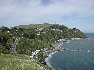
 Pukerua Bay, looking west. | |
 | |
| Coordinates: 41°02′S 174°53′E / 41.033°S 174.883°E | |
| Country | New Zealand |
| City | Porirua |
| Local authority | Porirua City Council |
| Electoral ward |
|
| Area | |
| • Land | 817 ha (2,019 acres) |
| Population (June 2024)[1] | |
| • Total | 2,070 |
| Train stations |
|
| Tasman Sea | Kapiti Island | Paekākāriki |
| Cook Strait |
|
Paekākāriki Hill |
| Plimmerton |
Pukerua Bay is a small seaside suburb at the southern end of the Kāpiti Coast, New Zealand. In local government terms it is the northernmost suburb of Porirua City, in the Wellington Region. It is 12 km north of the Porirua City Centre on State Highway 59, and 30 km north of central Wellington. In Māori, the words puke rua literally mean two hills but it is not clear to which hills the name refers.[2]
- ^ "Aotearoa Data Explorer". Statistics New Zealand. Retrieved 26 October 2024.
- ^ "Te Wiki o Te Reo Māori / Māori Language Week, Page 5: 1000 Māori place names". New Zealand History Online. New Zealand: Ministry for Culture and Heritage. 6 August 2019. Retrieved 14 May 2024.