Back پانچبول، نیو ساوت ولز Persian Punchbowl Polish Punchbowl, New South Wales Romanian پنچ بؤل، نیو ساؤتھ ویلز Urdu
| Punchbowl New South Wales | |||||||||||||||
|---|---|---|---|---|---|---|---|---|---|---|---|---|---|---|---|
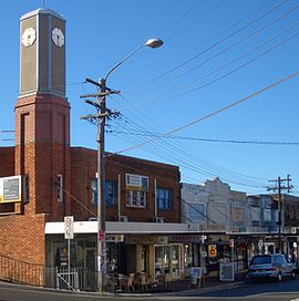
 The Boulevarde, Punchbowl c. 2007 | |||||||||||||||
 | |||||||||||||||
| Population | 21,384 (SAL 2021)[1] | ||||||||||||||
| Established | 1869 | ||||||||||||||
| Postcode(s) | 2196 | ||||||||||||||
| Elevation | 40 m (131 ft) | ||||||||||||||
| Location | 17 km (11 mi) south-west of Sydney CBD | ||||||||||||||
| LGA(s) | City of Canterbury-Bankstown | ||||||||||||||
| State electorate(s) | Bankstown | ||||||||||||||
| Federal division(s) | |||||||||||||||
| |||||||||||||||
Punchbowl is a suburb in the south west of Sydney, 17 kilometres (11 mi) west of the Sydney central business district, in the local government area of the City of Canterbury-Bankstown, in the state of New South Wales, Australia. At the 2021 census, Punchbowl had a population of 21,384.[2]
- ^ Australian Bureau of Statistics (28 June 2022). "Punchbowl (Canterbury-Bankstown - NSW) (suburb and locality)". Australian Census 2021 QuickStats. Retrieved 28 June 2022.
- ^ Cite error: The named reference
abswas invoked but never defined (see the help page).