| Putney Sydney, New South Wales | |||||||||||||||
|---|---|---|---|---|---|---|---|---|---|---|---|---|---|---|---|
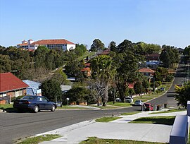
 Typical Putney streetscape | |||||||||||||||
 | |||||||||||||||
| Population | 4,097 (2021 census)[1] | ||||||||||||||
| Postcode(s) | 2112 | ||||||||||||||
| Elevation | 29 m (95 ft) | ||||||||||||||
| Location | 14 km (9 mi) WNW of Sydney CBD | ||||||||||||||
| LGA(s) | City of Ryde | ||||||||||||||
| State electorate(s) | Lane Cove | ||||||||||||||
| Federal division(s) | Bennelong | ||||||||||||||
| |||||||||||||||
Putney is a suburb of Northern Sydney, New South Wales, Australia. It is located 14 kilometres (9 mi) north-west of the Sydney central business district on the northern bank of the Parramatta River. Its local government area is the City of Ryde.
- ^ Australian Bureau of Statistics (28 June 2022). "Putney". 2021 Census QuickStats. Retrieved 3 February 2024.
