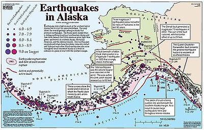
The Queen Charlotte Fault is an active transform fault that marks the boundary of the North American plate and the Pacific plate.[1][2] It is Canada's right-lateral strike-slip equivalent to the San Andreas Fault to the south in California.[3] The Queen Charlotte Fault forms a triple junction south with the Cascadia subduction zone and the Explorer Ridge (the Queen Charlotte Triple Junction). The Queen Charlotte Fault (QCF) forms a transpressional plate boundary, and is as active as other major transform fault systems (i.e. San Andreas, Alpine) in terms of slip rates and seismogenic potential.[4] It sustains the highest known deformation rates among continental or continent-ocean transform systems globally, accommodating greater than 50mm/yr dextral offset.[5] The entire approximately 900 km offshore length has ruptured in seven greater than magnitude 7 events during the last century, making the cumulative historical seismic moment release higher than any other modern transform plate boundary system.[6]
The fault is named for the Queen Charlotte Islands (now Haida Gwaii) which lie just north of the triple junction. The Queen Charlotte Fault continues northward along the Alaskan coast where it is called the Fairweather Fault.[7] The two segments are collectively called the Queen Charlotte-Fairweather Fault System.
- ^ Trehu, A. M.; Scheidhauer, M.; Rohr, K. M. M.; Tikoff, B.; Walton, M. A. L.; Gulick, S. P. S.; Roland, E. C. (2015-03-03). "An Abrupt Transition in the Mechanical Response of the Upper Crust to Transpression along the Queen Charlotte Fault". Bulletin of the Seismological Society of America. 105 (2B): 1114–1128. Bibcode:2015BuSSA.105.1114T. doi:10.1785/0120140159. hdl:2152/43270. ISSN 0037-1106. S2CID 128679814.
- ^ Walton, M. A. L.; Gulick, S. P. S.; Haeussler, P. J.; Roland, E. C.; Trehu, A. M. (2015-04-14). "Basement and Regional Structure Along Strike of the Queen Charlotte Fault in the Context of Modern and Historical Earthquake Ruptures". Bulletin of the Seismological Society of America. 105 (2B): 1090–1105. Bibcode:2015BuSSA.105.1090W. doi:10.1785/0120140174. hdl:2152/43271. ISSN 0037-1106. S2CID 59376353.
- ^ Rohr, K. M. M.; Tryon, A. J. (2010). "Pacific-North America plate boundary reorganization in response to a change in relative plate motion: Offshore Canada". Geochemistry, Geophysics, Geosystems. 11 (6). Bibcode:2010GGG....11.6007R. doi:10.1029/2009GC003019. ISSN 1525-2027. S2CID 129230105.
- ^ Yue, Han; Lay, Thorne; Freymueller, Jeffrey T.; Ding, Kaihua; Rivera, Luis; Ruppert, Natalia A.; Koper, Keith D. (November 2013). "Supershear rupture of the 5 January 2013 Craig, Alaska ( M w 7.5) earthquake: 2013 CRAIG EARTHQUAKE SUPERSHEAR RUPTURE". Journal of Geophysical Research: Solid Earth. 118 (11): 5903–5919. doi:10.1002/2013JB010594. S2CID 3754158.
- ^ Brink, U. S. ten; Miller, N. C.; Andrews, B. D.; Brothers, D. S.; Haeussler, P. J. (2018). "Deformation of the Pacific/North America Plate Boundary at Queen Charlotte Fault: The Possible Role of Rheology". Journal of Geophysical Research: Solid Earth. 123 (5): 4223–4242. Bibcode:2018JGRB..123.4223T. doi:10.1002/2017JB014770. hdl:1912/10462. ISSN 2169-9356. S2CID 133742253.
- ^ Bostwick, T. (1984). A re-examination of the August 22, 1949 Queen Charlotte earthquake.
- ^ Brothers, Daniel S.; Miller, Nathaniel C.; Barrie, J. Vaughn; Haeussler, Peter J.; Greene, H. Gary; Andrews, Brian D.; Zielke, Olaf; Watt, Janet; Dartnell, Peter (2020-01-15). "Plate boundary localization, slip-rates and rupture segmentation of the Queen Charlotte Fault based on submarine tectonic geomorphology". Earth and Planetary Science Letters. 530: 115882. Bibcode:2020E&PSL.53015882B. doi:10.1016/j.epsl.2019.115882. hdl:10754/660310. ISSN 0012-821X. S2CID 210615976.
